Saturday, April 27, 2024 Apr 27, 2024
72° F Dallas, TX
Advertisement

FrontBurner

A Daily Conversation About Dallas
Policy

Urban Expert on TxDOT’s I-345 Options: ‘You Can Do Better’

Peter Simek
|
Image
Google Maps satellite image

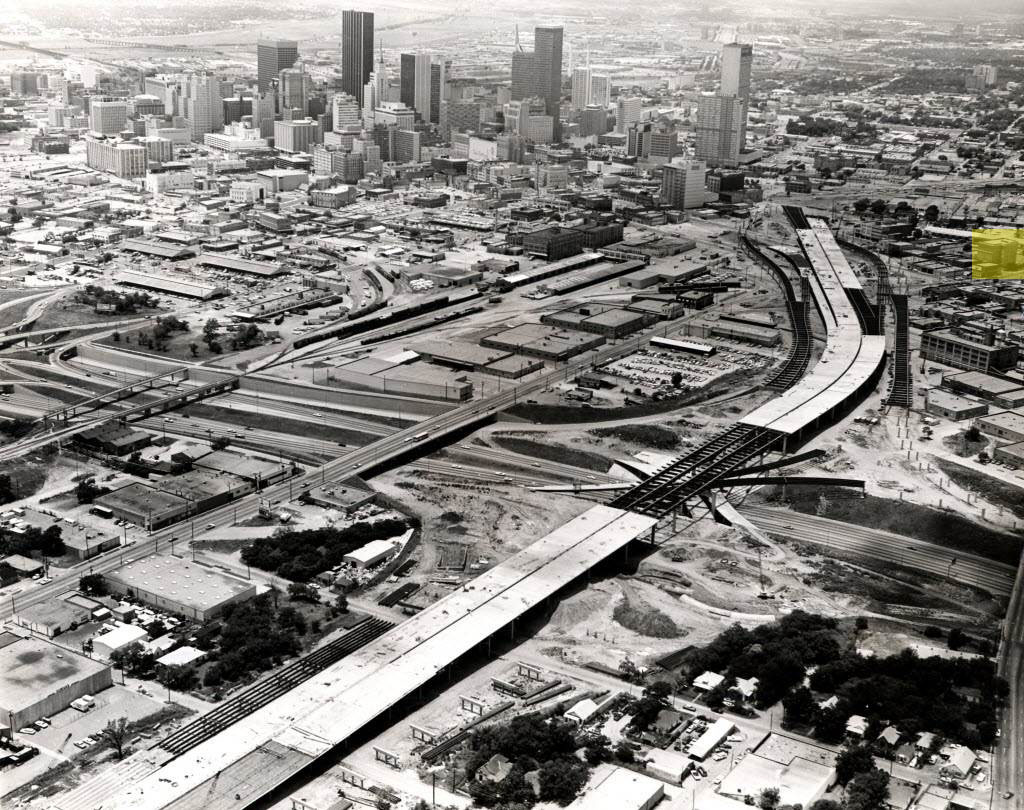
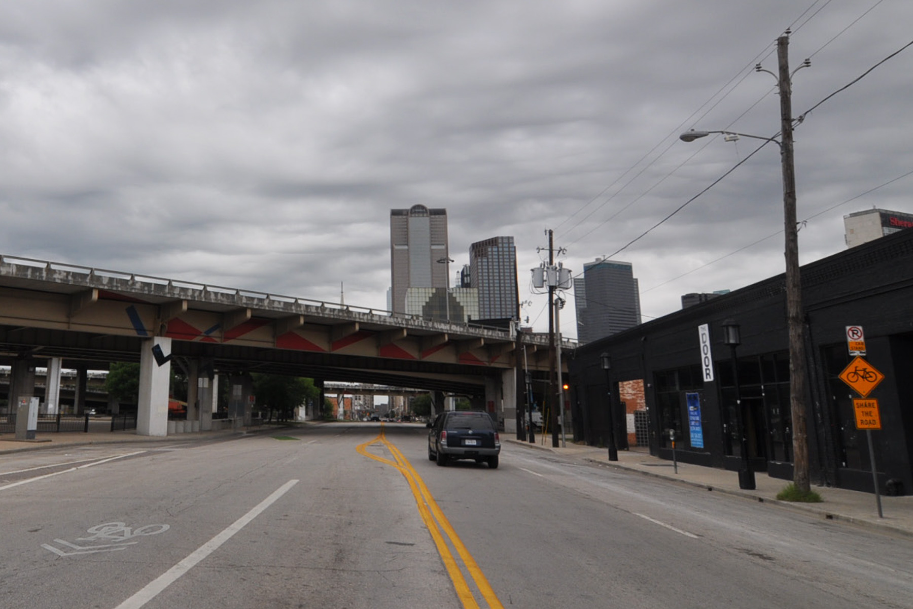
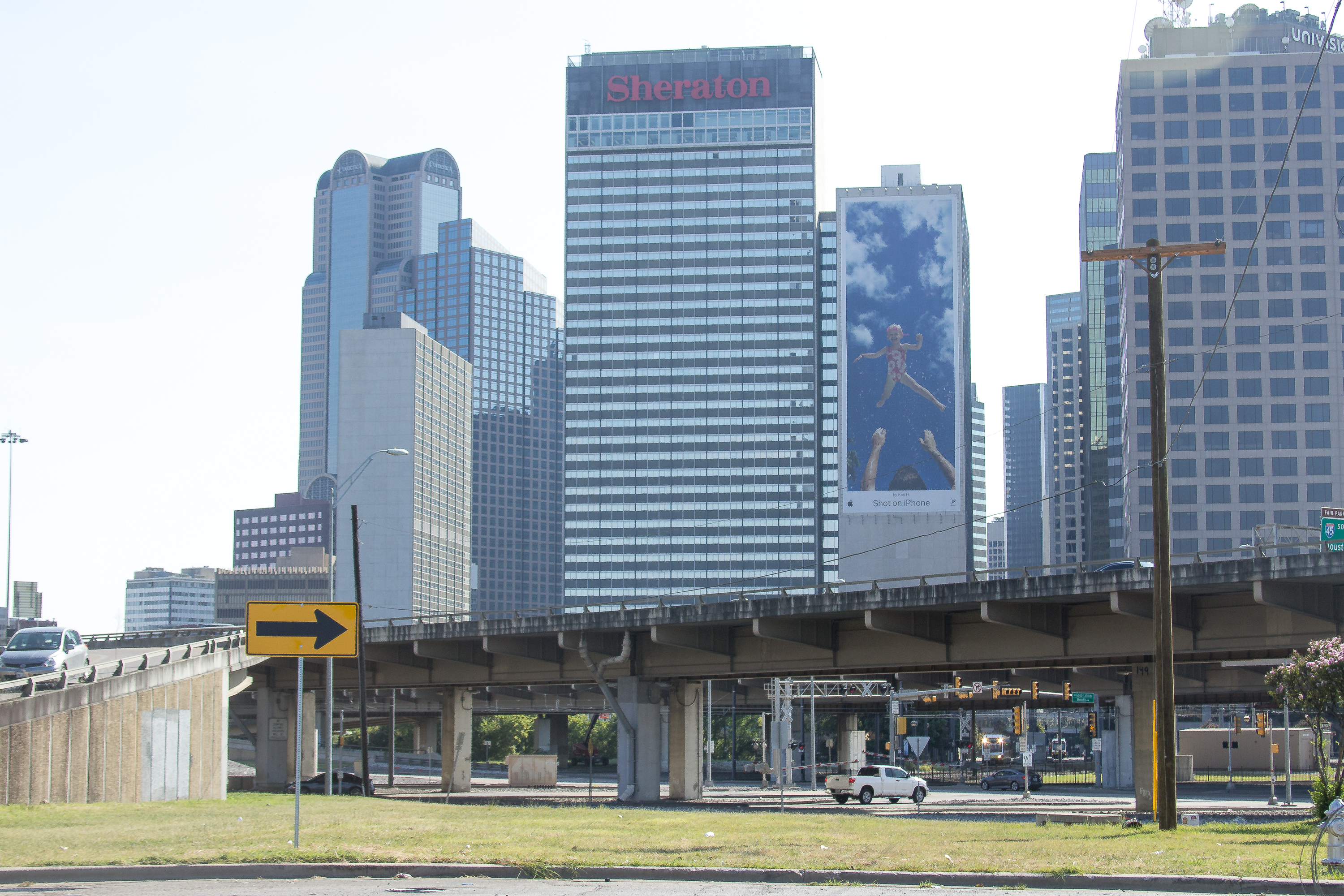
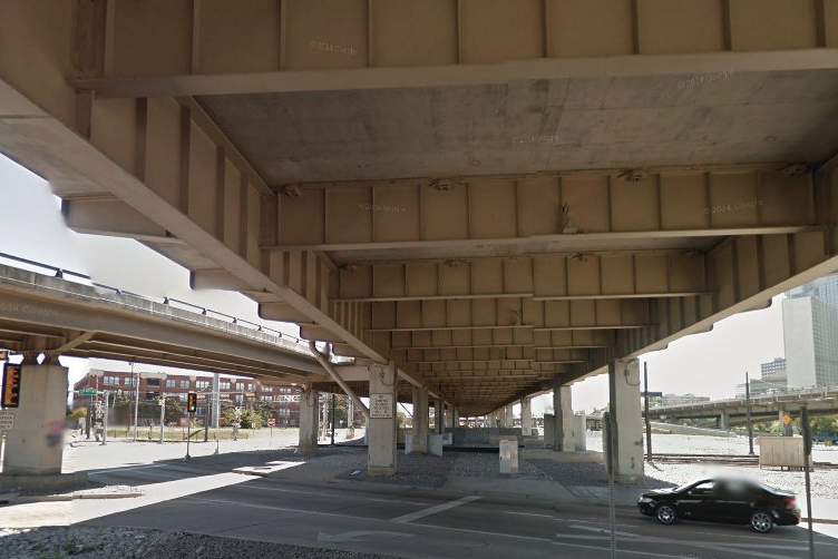
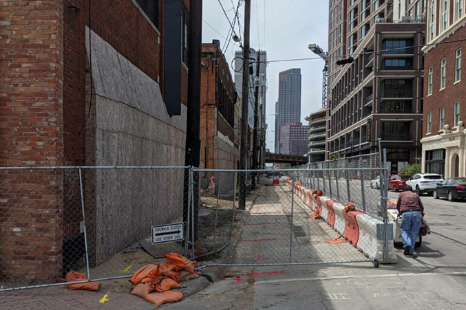
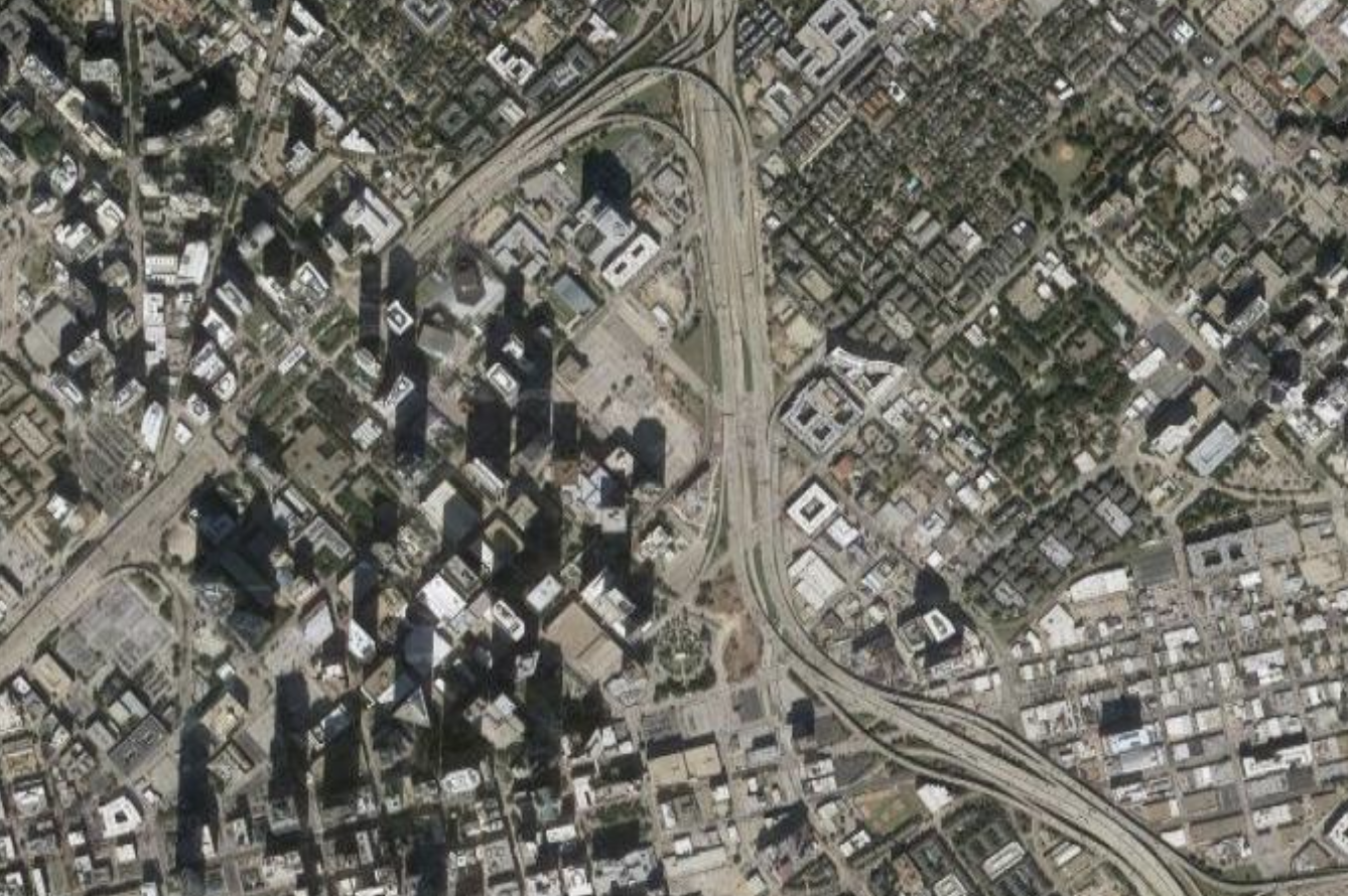
Last month, the Texas Department of Transportation unveiled initial designs for replacing or removing I-345. TxDOT included five possible options for the future of the road that cuts through Deep Ellum and which, as we have argued for a number of years, should ultimately be torn down. They include:

  • Doing nothing
  • Rebuilding the existing road
  • Replacing I-345 with a trenched highway
  • Removing the highway altogether
  • A “hybrid” option that includes some removal and some trenching

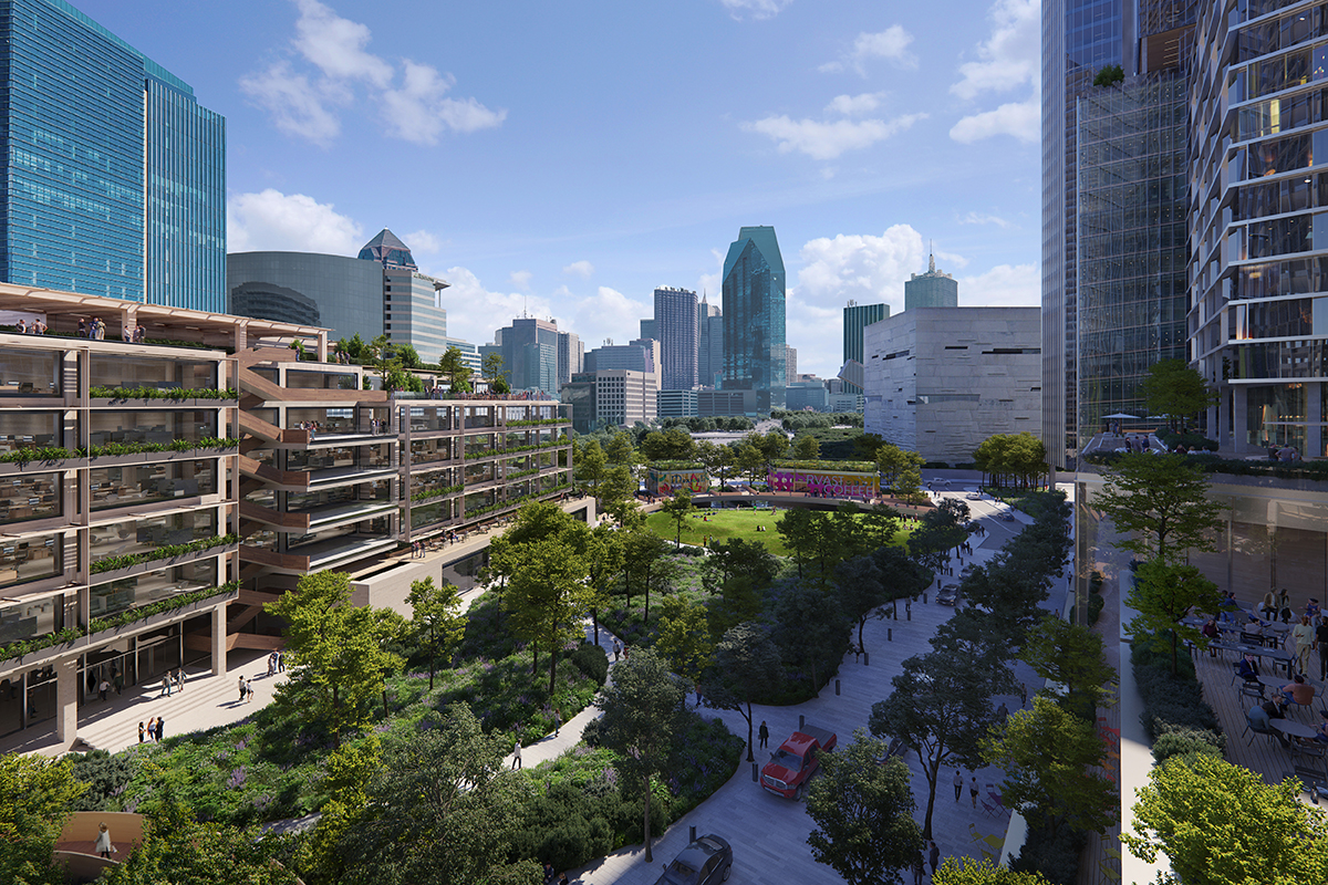
Last Thursday, the Coalition for a New Dallas hosted a conversation with renowned urban planner Peter Park to discuss the options. (Full Disclosure: The Coalition was founded by D Magazine’s late founder Wick Allison.) Park’s takeaway: the designs aren’t there yet. In fact, Park even found TxDOT’s design for I-345’s removal to be lacking and said that none of the early plans for the future of I-345 fully maximized the full potential of what a reimagined I-345 could mean for Dallas.

“I think you can do better,” Park told moderator Patrick Kennedy, who started this whole I-345 teardown business.

In 1997, the fenced-in Northend Dallas apartments didn’t occupy an important connection between Victory Park and Uptown. The 540-unit apartment complex went up on 11 acres here decades before this part of Dallas went vertical with dense development. Now the city agrees it is time these apartments come down, replaced with something that makes more sense in its present surroundings.

The City Plan Commission last week unanimously approved what the landowner, Hunt Realty, has planned for these 11 acres. Hunt is now one council vote away from rezoning land bordered by Houston Street, Field Street, and Nowitzki Way to pursue an ambitious mixed-use high-rise development that its executives believe is a far better fit for this part of Dallas. At least 1.5 acres of public green space would be flanked by skyscrapers and a low-rise building made of timber. Hunt hopes to tie Victory Park to Uptown through what it has branded an “urban arboretum” that will exist in the middle of the property and contain pedestrian connections to points beyond it.

The project is in a very early stage of planning. The city’s approval is pending a conceptual master plan, which will likely dictate how many buildings there can be, how high they can go, how far apart they can be from one another, and their distance from the street and sidewalks. The company has suggested in news reports heights of more than 80 stories, which existing zoning allows. (Existing zoning also only allows multifamily on this plot, which necessitates the zoning change.)

Hunt anticipates the project will take 20 years to complete. It would include office, retail, hotel, and housing. The development includes ground-level rental space facing existing streets like Houston and Field, but the skyscrapers will likely open to the park. During the plan commission meeting, the company said it was aiming to reserve 5 percent of its units for residents making between 51 percent and 60 percent of the area’s median income. (That would be about $27,050 to $32,454, per the city’s data.) 

As this land exists today, a black fence surrounds the apartment complex, blocking access from all directions. That needs to change.

“It is the epicenter of the Victory Park, Uptown, Katy Trail, Klyde Warren Park, Perot Museum, and the [American Airlines] Center,” said City Plan Commissioner Wayne Garcia, who represents downtown and Uptown in District 14. “You guys have the opportunity to make this the center point of everything.”

DART’s planned D2 subway line will have a stop nearby, which the developers are including in their plans. Too, the planned Hi Line Connector will connect the Katy Trail to the Design District, making the bike lanes along Houston Street an important bridge. The plans include sidewalks with widths of between 8 and 12 feet. Further, Houston Street also leads into the West End and farther south to the old Dallas Morning News headquarters, which is slated for its own mixed-use overhaul.

When Dallas’ newest City Council members were sworn in Monday, Mayor Eric Johnson gave a speech about getting back to the basics of city governance: things like building permits, trash pickup, public safety, economic development. On Wednesday, City Council member Cara Mendelsohn recalled that commitment as the new council was briefed on a plan to improve Dallas’ old and busted sidewalk system. Fundamentally, the city has an obligation to make sure people can move about safely. A sidewalk is about as basic as it gets.

As most people who have done any serious walking in Dallas can attest, the city doesn’t always get the basics right. We’ve written before about the city’s estimate that Dallas is missing roughly 2,000 miles of sidewalk. If you’re lucky enough to have a sidewalk, odds are good it’s uncomfortably narrow, or pitted and cracked, or for some reason studded with straight-down-the-center decorative light poles that force you to run an obstacle course every time you go for a stroll. Now imagine getting around on that kind of sidewalk if you’re in a wheelchair, or pushing a stroller.

Robert Perez, director of the city’s public works department, told council members that it would take a little under $2 billion to totally fix this: $1 billion to fill in the 2,000 miles of missing sidewalk, and about $976 million to fund 40 years of maintenance on the sidewalk we already have. This year, the city put about $10 million toward sidewalks. Perez says his department will ask for about $8 million a year for sidewalks to come from the city budget, with plans to get another $12 million a year from a bond package that should come up a few years down the road.

That’s $20 million a year for sidewalks. Meaning it would take about 100 years to “fix” Dallas’ sidewalk system. If they’re not riding around in flying electric cars—or hiding out from cannibals in a post-apocalyptic wasteland—your great-grandchildren will be able to follow the sidewalk all over Dallas.

Last week, developer and incremental growth enthusiast Nathaniel Barrett posted a couple old newspaper clippings to Twitter. They are both reports on Deep Ellum, one from 1966 and another from 1971, and they are about the same thing: the death of the neighborhood.

The timing of the articles is curious. In between 1966 and 1971, much of Deep Ellum was leveled to make way for what one of the stories describes as a “10-lane freeway leg,” which we know today as I-345—or that little stretch of concrete that separates Deep Ellum from downtown about which we have made such a fuss over the years. These two old news stories help explain the fuss.

In fact, taken together, the articles offer a unique and valuable historical document. They don’t merely capture the look and feel of the neighborhood during this pivotal – and fateful – stretch of its history, they also reflect some of the attitudes and mentalities that surrounded the tumultuous construction of the highway. Reading them, one thing stands out: this city’s almost immediate obliviousness toward the violence and devastation wreaked upon its historic neighborhoods by highway construction.

Advertisement
Transportation

I-345 Back on CNU’s ‘Freeways Without Futures’ List

Peter Simek
|
Image
Munn Harris Architects

On the heels of that New York Times report on the proliferation of highway removal projects in U.S. cities, the Congress for the New Urbanism has released its almost annual list of “Freeways Without Future.” Dallas’ I-345 has become a perennial on the list after first being featured back in 2014. The 2021 list has expanded to include 15 roads, including I-35 in Austin and I-244 in Tulsa– a reflection, perhaps, of how the idea of urban highway removal has taken hold throughout the country ahead of expected new federal funding for such projects.

The write-up on I-345 highlights the progress that has been made on the road, particularly since the release of the CityMap study, the follow-up Toole Design Group-led “Framework Plan,” and TxDOT’s ongoing work on the project. TxDOT will make its latest engineering studies public during a virtual meeting and two in-person sessions all set to take place on June 22. At those meetings, the agency is expected to present multiple options for the highway’s future.

As CNU points out, a “street network option” remains on the table:

Dallas gets only a passing mention in this extensive New York Times dive into the cities around the country that are trying to remove urban highways. If you’ve been following this debate over the years — and you should have been — you’ll know much of the top-line info in the piece.

  • Cities “basically destroyed themselves,” says UCONN professor Norman Garric, by smashing neighborhoods to build roads.
  • The building of the federal interstate highway system often targeted Black neighborhoods. “There is racism physically built into some of our highways,” says DOT chief Pete Buttigieg, slightly understating the point. (If you want to know where Dallas’ freedmen’s towns were, run your finger along a map of the city’s highway network.)
  • Regarding Dallas’ effort to remove I-345, which runs between downtown and Deep Ellum, the Times reports that this city is “facing pressure from local residents and activists to address the pollution, noise, and safety hazards brought by the mega-roads.” That’s fair statement, but I would add to the motivations the desire to create a new, equitably minded downtown neighborhood while re-stitching the urban street grid; generate a once-in-a-lifetime economic boost to the inner city; and reverse the outward spread of economic growth by bringing jobs back to the urban core.

The news hook for Times interest in highway teardowns is the Biden Administration’s infrastructure plan. The version of the plan released in March proposed $20 billion for highway removal. The bill that is being hashed-out by Democrats in Congress translates that proposal into new federal funding for highway teardowns over five years. The Department of Transportation has also created grants for cities to kick-start the process. In other words, new federal policy may create an accelerant that could make longterm highway removal plans more imminent.

Collin Yarbrough spent 8 years working as a pipeline engineer for Atmos Energy before he quit to focus on Full Circle Bakery, the community service-minded cookie-making operation he had founded with his mother—its proceeds go entirely to nonprofits like CitySquare. Around the same time, in 2019, he went into seminary at SMU’s Perkins School of Theology. It’s a background that in many ways made the Lake Highlands native uniquely prepared to write a book about how years of infrastructure development shaped by racist public policy turned Dallas into one of the most unequal cities in the U.S.

Paved A Way: Infrastructure, Policy and Racism in an American City, is available now on Amazon and coming soon to a Dallas bookstore near you. In the book, Yarbrough tells the stories of neighborhoods like Little Mexico, whose erasure began with the construction of the Dallas North Tollway, although there are still some remnants of the once-thriving Hispanic community in what is today Uptown. There’s Deep Ellum, split by I-345. And Fair Park, where Black neighborhoods were seized by eminent domain and paved over with parking lots to bring more White people to the State Fair of Texas.

Paved A Way shares some DNA with books like The Accommodation and White Metropolis, which similarly cover how a history of racism and inequality shaped the Dallas of today. Yarbrough’s book is also a call to action.

“These communities are still fighting,” he says. “Little Mexico may be gone, but West Dallas is having to face concrete batch plants coming in and trying to grapple with Trinity Groves. It’s the same thing, just in a different location with different names and different actors. An engaged coalition of community members is, by and large, one of the most powerful things that I’ve seen in Dallas and in other cities that can really make an impact on keeping this kind of injustice from repeating.”

I got Yarbrough on the phone this week to talk about Paved A Way and the story behind every highway. This interview was condensed and edited for clarity.

Urban Design

The 50-Mile Loop Trail Is One Step Away From Beginning Construction

Matt Goodman
|
Image
courtesy of Circuit Trail Conservancy

The 50-mile Loop Trail is one council vote away from beginning construction. The Park and Recreation Board last week approved a $5.7 million construction bid for the first phase of the project, which will pave a new trail just below White Rock Lake through what is now the Tenison Glen golf course. That course, as you’ll recall, will soon be reduced from 18 holes to 9 and turned into a nature preserve to follow the findings of the Samuell Grand Master Plan. The trail will run through it. (The county will pay for $3.5 million, while the city’s bond program covers the rest.)

The Loop connects 39 miles of existing trail and creates a new stretch that will extend south into the Trinity Forest from near White Rock Lake. This is called the Trinity Forest Spine Trail, and the first phase splits off from the Santa Fe Trail, goes through Tenison, and concludes at Samuell Boulevard. The first construction piece will also include a spur at Highland Road just east of Tenison Park. The city has spent nearly $4 million on reconstructing Highland Road near the Forest Hills neighborhood, and the spur will tie into new cycling infrastructure there. The Dallas City Council is scheduled to vote on approving the construction bid during its June 9 meeting. (The county will pay for $3.5 million, while the city’s bond program covers the rest.)

Philip Hiatt Haigh, the executive director of the Circuit Trail Conservancy, says construction on the first phase will begin by July, pending council approval.

Advertisement

From a colleague, the scene on Bonita Avenue in East Dallas:

By the usual unhappy standards of Dallas hating pedestrians, this doesn’t rank as too egregious. At a glance, it looks like these sections are blocked off for what I would assume is necessary work on below-ground utilities or on the sidewalk itself. The holes are clearly marked, so you’re not falling in without some warning. And this residential street, while close to a good deal of activity on Henderson, may not be getting that much traffic. Assuming you’re not in a wheelchair or on crutches—a big assumption that shouldn’t really be made as it relates to these things—you could probably detour into the roadway without too much risk to your person.

But still, even with those caveats, come on. And with the city taking a closer look at its many miles of busted or nonexistent sidewalk, it’s worth keeping an eye on where our sidewalks end.

Send your photo evidence of Dallas hating pedestrians to [email protected]. For more in this series, go here.

Don’t call it a comeback. Not yet. But electric rental scootersbanned from the streets of Dallas last fall after two wild years that saw them both hailed as an important mobility option in a city freeing itself from a car-centric past and decried as a menace to law-abiding citizens everywherecould be returning sooner rather than later.

“We’ve heard a lot from community groups and locals who want scooters back in Dallas,” says Alex April, the head of government partnerships for Spin, a Ford Motor Co. subsidiary that pitched its scooter service at City Hall last week. “Spin wants this to be done in a responsible manner to make sure this program is successful long-term.”

I couldn’t get anybody from the city’s transportation department on the phone, and as of Friday morning hadn’t heard back from spokespeople for Lime and Bird, operators whose names should be familiar to those who recall Dallas’ last scooter heyday. However, Councilman David Blewett told Channel 4 that next month the city will ask scooter companies to make their respective cases for a return to Dallas. He predicted scooters would be back “in a safe and efficient manner” at some point this year.

“There is no way this goes well,” sneered The Dallas Morning News’ editorial board.

Well, not with that attitude it won’t.

Amy Meadows is the CEO of Parks for Downtown Dallas, the nonprofit foundation that has partnered with Dallas and its parks department to create more greenspace in the city’s urban core. The foundation has been tasked with developing four downtown parks, which will be owned by the city.

Two of those parks have opened in the last several years. The Dallas Morning Newsarchitecture critic hailed the technology-oriented West End Square as “a model for how the delicate relationship between the urban landscape and our connected way of living might be navigated,” and Pacific Plaza beautifully replaced one of downtown’s many unnecessary parking lots with a lawn, pavilion, and ample shade from the Texas sun. Carpenter Park, in the works now on the east side of downtown, will be the largest downtown park. Its 5.6 acres are set to include rescued public art plus a basketball court and dog park, along with other amenities. Harwood Park, where crews will break ground later this year, is on deck.

The development of these parks, combined with the success of Klyde Warren Park (owned by the city and privately managed by a separate foundation), have accompanied and helped spur a transformation of the city’s urban core. Downtown boosters say the COVID-19 pandemic hasn’t thrown that revitalizationoriginating in part from Boeing’s 2001 snub of our then-dreary downtownoff track. Parks for Downtown Dallas is thinking long-term, anyway. “We were trying to design and build parks that are 100-year parks,” Meadows says. “They’re going to be here for a very long time.”

If anything, the pandemic made clear just how necessary parks are to making downtown more walkable, more liveable, greener and much coolerliterally. “We’ve heard from a lot of people living in high-rises downtown that these parks were really wonderful respites during COVID,” Meadows says. “These parks are more desired now than they were before.”

I got on the phone with Meadows to talk about, among other things, how to judge whether a park is “working” and how the fate of downtown’s largest greenspace is tied to the future of I-345. This interview was condensed and edited for clarity.

We know it’s been a while since you’ve seen this feature. And we also know that the perambulating difficulties across the city of Dallas haven’t let up. So we’re re-launching Dallas Hates Pedestrians, starting in Deep Ellum. This is a classic example of what this feature has tried to raise awareness of: sidewalks are not meant to be rental space for construction. This image was taken at Good Latimer and Elm Street last month, but it has been under construction for a while. The construction has swallowed the sidewalks, with the Epic on the north side of the block and the smaller storefronts on the south. Here is how Google Maps captured it in February of 2020:

Advertisement