For whatever reason this morning, I woke up thinking about Austin. I have no idea why. Perhaps it was a past question rolling around in the ol’ sub-conscience (I have a tendency to stew over such things half-asleep all night long), “why is Austin’s traffic so bad?” Aren’t they a bunch of hippies riding around on bikes and college students?
Like us, their biggest issues are related to mode share. Too many people in cars competing for too little space. Of course, the people in cars is an outgrowth. It’s not the root of the problem. People are making rational decisions for themselves within their context. What about the context?
Again, like us, Austin sprawled primarily northward. Most of the commutes to the 11 square mile job core are coming from due north. Of commutes 10 to 24 miles long, 65% are from the north. That north/south imbalance is a land use problem. But there is also a network problem.
Downtown Austin is an island. Despite just having parallel N-S freeways and no E-W freeways through the core (which were proposed all over the place but prevented), sprawl happened in a N-S manner and very little E-W. That’s long trips. Of short trips, those two N-S highways became enormous barriers to urban growth in the core, thus reinforcing the N-S inertia. How did the north win? That’s an answer I discuss in many of my highway presentations. Inertia follows the favored quarter. And follows it. And follows it. That’s the inherent conservatism of investment. Profit motive follows profit past. Investment is risk averse.
Even though Austin doesn’t have E-W freeways it has Town Lake to the south. Since it is expensive to build bridges, the grid is disrupted. But what about to the North? nd that was my ah-ha! moment.
It’s UT. There is one connection N-S through the campus and considering how many students are milling about, you probably don’t want to use it as a cut-through. You must go around what might as well be a 1 square mile lake according to the grid network. That pushes a lot of traffic to four N-S corridors: 35 and MoPac as the highways and Guadalupe and Lamar as arterials. That’s it. Considering there are 233,000 jobs in this area (up from 195k in 2001) and most of them are coming from the north, that’s a lot of people competing for very little capacity, often at the same time (rush hour).
Yes, this post is still about Dallas despite the detour to our capital to the south. My concern with downtown Dallas and the surrounding neighborhoods is the same story. Even though Austin doesn’t have a highway noose, they have the same island effect disrupting the multiplicity of choice that a highly interconnected grid provides.
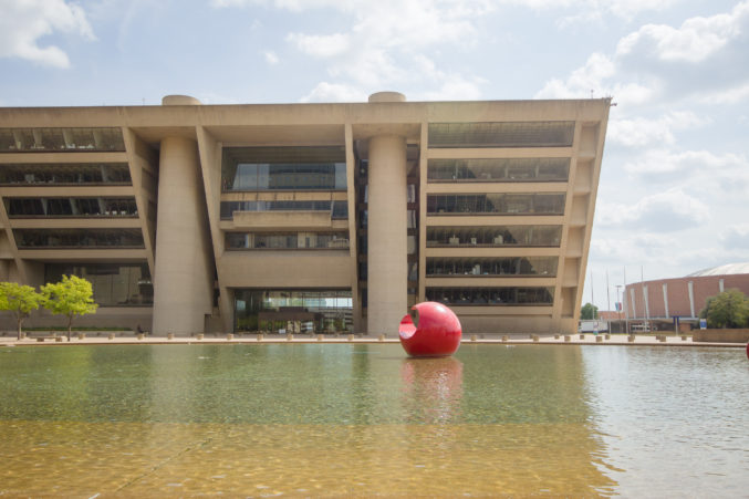
While praise is lavished on Klyde Warren Park, let’s not forget about what the highway did to the grid in the area (as well as the neighborhood):
Below is the State-Thomas area in the 1950’s. It was one of the Freedmen’s towns of Dallas. The way I’ve heard it described is that it was the Harlem of Dallas. Working class, but vibrant.
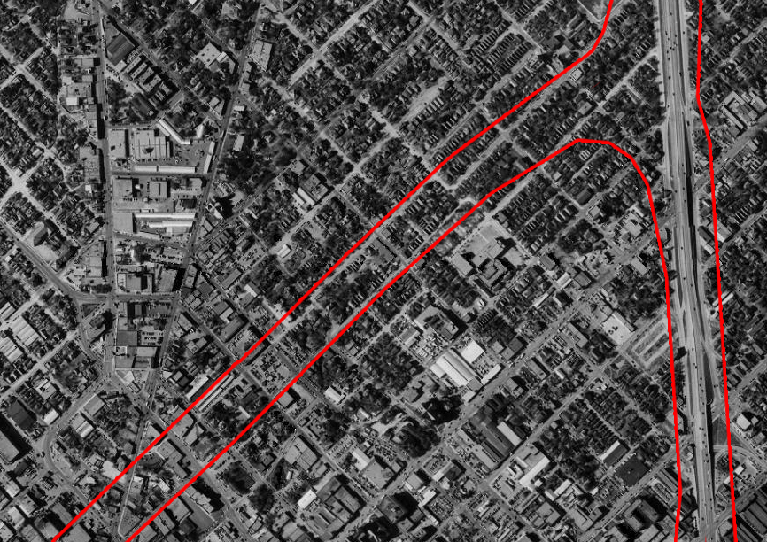
Shown in red is the current footprint of Woodall Rodgers expressway and Central Expressway (345/75). Central as shown there was the first iteration of it as a highway. As it entered downtown, it scaled down to a surface street. Going back through historic census data in the area, the population densities of the surrounding census tracts ranged from 15,000 to 20,000 per square mile. Unemployment was 3%. It was 86% black, however remember this was the 1950’s so median household incomes were the equivalent of $13k/year.
Incomes rose dramatically by the 1970 census. Median household incomes rose to over $30k/year. However, population density dropped to just over 7,000/sq mi. Why? Perhaps because incomes rose, the city desegregated, and more areas of the city were available to live in. The other reason for population density decline though? Well, you’re answer is what do we do to black neighborhoods? We blast a highway through them.
See 1972 aerial as 345 and Woodall Rodgers are under construction:
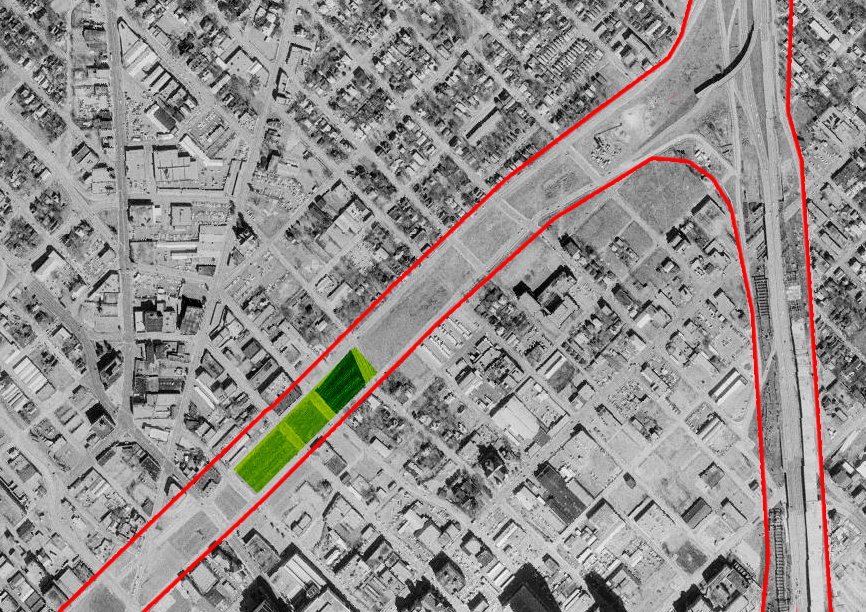
The current location of Klyde Warren Park is shown in green. However, what’s important to note here is that this aerial was presumably taken as mayor Erik Jonsson ordered the water supply cut to TxDOT’s work because he was so opposed to another elevated freeway cutting through town. They were preparing to build an elevated highway much like what 345 is currently. The grid is still largely intact. Both an elevated and a sunken highway can maintain cross connections, however elevated highways have a more pronounced negative effect on property values. In exchange for that implicit cost, a sunken highway costs more upfront. The presence of the grid connections above however is indicative of an awareness of the importance of these local connections.
Except…
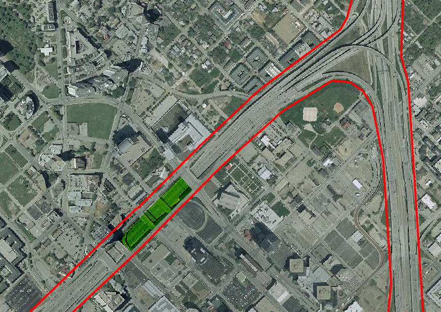
Most of them are gone.
By 1990, population density had plummeted to 984/sq mi. Unemployment was only at 5%, but everybody was gone. The area was now divided into three: what is now the uptown side, the east Dallas side, and downtown. In 1990, there was nobody in the adjacent downtown census tract. Incomes to the east had fallen back down to $15k, while in the uptown side they remained steady at $34k.
As connections across barriers and between adjacent neighborhoods become scarce, it puts extra pressure on those few connections. They funnel traffic while the other streets that have been severed lose life as dead ends. Rather than a stable grid that filters traffic and agglomerates economies, some streets become invaded by cars, others get abandoned entirely. Don’t believe me? Just compare Pearl (invaded) and Harwood (abandoned) sometime. Neither is a good condition. It’s like gardening with a fire hose.
Connectivity is critical. However, all connectivity is not all the same. Regional connectivity, while critical to the region on the whole, is more often destructive and more disconnective than it is connective in the urban core, where local connectivity is critical. Just today I came across a study showing how job sprawl (that inertia I referred to above), is particularly harmful to the poor as it prevents access to entry level jobs (via infrastructure-coerced car-dependence) and the first step up the ladder out of poverty. Catering to it is like allowing everyone to leave and then pulling up the ladder of opportunity behind them.
Local connectivity is the grid. It is also access to opportunity when it’s coupled with density and livability. We sever it at our own risk.
I suppose a bandage on an open wound feels better. Maybe it stops the bleeding. But what if it grows gangrenous? Hey, at least there’s free parking.