 I can’t believe I never thought of this before. I suppose it’s one of those things that afflicts us all, that infrastructure is static and inevitable. That there is nothing we can do about it in our learned helplessness. After all, we’re told these are “improvements” and “needed” and “gotta move those cars” and “get this here road up to level of service A.” The implication of course being that LOS A is a good thing. Because it isn’t an F. Needless to say, just about every great road in any city operates at a D level or “worse” in the parlance of transportation planners, that rare species that cares not for the negative externalities and indirect casualties of their war on the bogeyman of congestion happening outside of their incredibly narrow scope of view. Those casualties are our cities.
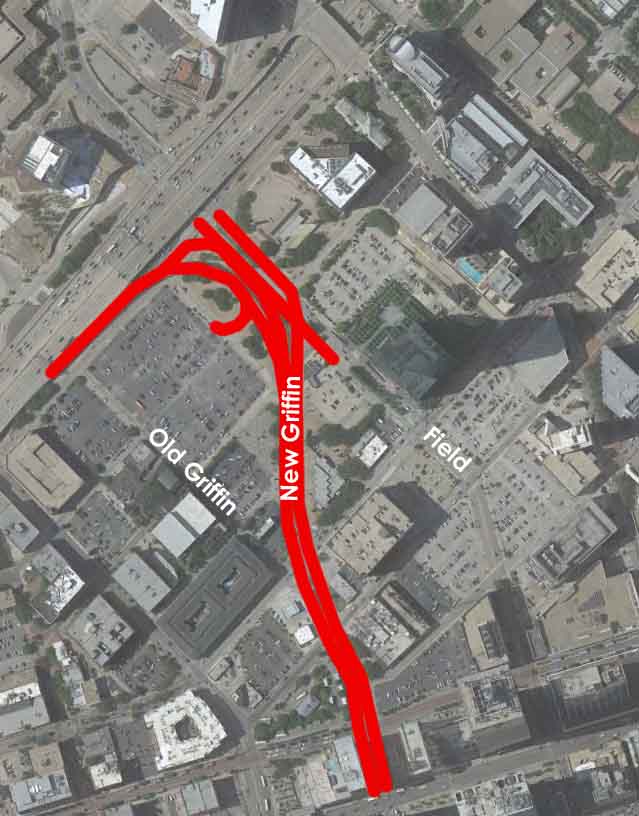
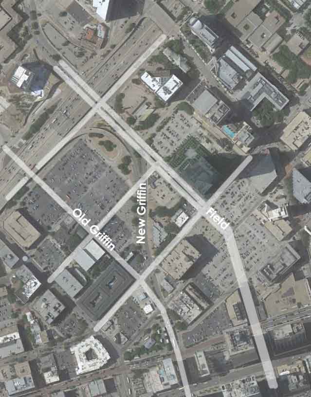
All of this brings me to Griffin Street, the road that was relocated, I’m guessing sometime around the time Woodall Rodgers Freeway was constructed to accommodate the distance needed to cover the elevation change for the exit ramp to traverse down to the city streets from the elevated freeway. No matter. The history is relevant. What matters is not why it’s there, but rather the present of what has it done and what is a preferred future for this property? How can we leverage something better particularly as a few projects have died on this New Griffin site and as Tim Headington is poking around the Field Street surface parking lots.
Macro-effect of disconnectivity displaced people from downtown to the ever increasingly bleeding edge of sprawl. The micro-effect is also interesting. Griffin, acting as the access route to/fro the regional highway system displaced Field as a primary arterial, though Field has retained its size. The new Griffin killed any existing or potential development and vitality by slicing through developable blocks and carving them into uselessness. And by doing so it also killed Field by sapping it of its lifeblood.
Field no longer has the traffic to fill that capacity however and in turn, everything around it dies so that highest and best use of it too is as surface parking lot. Looking specifically at the traffic counts Field runs about 9,000 vehicles per day or about 29% of the capacity its built for. Griffin has quite a bit of noise year to year but it seems to average around 15,000 to 18,000 cars per day or about 35% of its 6-lane capacity. You can also bet the vast majority of this is not local traffic.
——
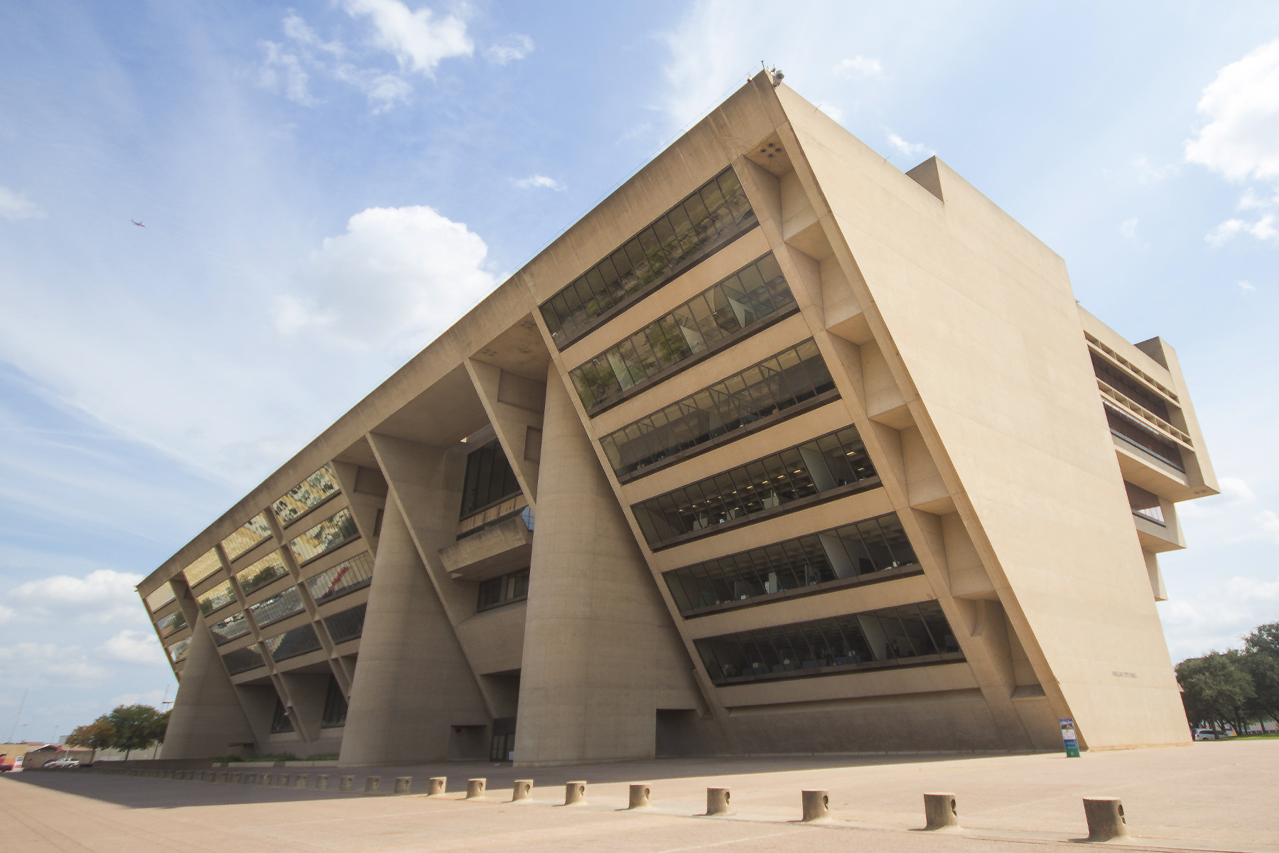
We’re left with a decrepit old fire station, a 7-11 gas station, a fedex store, and a drive-thru bank (that if memory serves might be closed? I don’t know. I don’t have much use for drive-thru banks and frankly loathe any that occupy downtown land.). All of that on the 14 acres the New Griffin swath cut through, presumably knocking several buildings down and condemning private land. All in the name of “public good.” Unfortunately, we’re not better off for it. Unless a few drive-thrus seems like a good use of downtown land to you.
Let’s take a look at how to kill 2 birds with one stone, ie leveraging both the Griffin area (by adding land) and the Field area (by adding traffic). Excuse the incredibly quick, sketchy photoshop work:


Hey look! It’s buildings. But not by magic like most planning. We’re actually repurposing the street network in the direction needed by both the Field and Griffin sites. Field needs more activity, Griffin needs more developable land.
Also, don’t pay much attention to the layout and design. For rhetorical purposes only. The only thought that went into it was 1) restitch grid 2) apportion developable, walkable block sizes 3) throw a couple of open spaces in there. In this case I gave the aquarium and FountainPlace new front door open spaces.
——
With Field being retrofitted back to a two-way road, it can and should return to function for the size and traffic of the primary street it was originally intended as. By abandoning the New Griffin and realigning it as the Old Griffin we accomplish several things:
- The Field properties have increased value and viability as mixed-use commercial and residential developments. Right now, without the traffic the only value here is as residential. Tim Headington should like that idea.
- Abandoning New Griffin gives the city leverage (in the way of 4 acres of land to toss into a deal) for packaging a partnership deal with the current private landowners to develop this land to add new residential which would support West End, Victory, and the new Field commercial/mixed-use mentioned previously.
- Griffin can better tie this part of downtown with Victory by bending the existing right-of-way which sits in the surface parking lots north of Woodall Rodgers into Market Street through Victory.
- The Fire Station can be relocated into one of the new mixed-use developments. I’m sure the Firefighters would tell you they need better facilities.
First, it should also be noted that you should freak out that Field narrows as it gets to the core when it begins handling more traffic. All roads should narrow as the grid around them tightens and strengthens. The lost capacity is handled by the increased capacity of the complex grid around it and traffic filters, as it should.
I haven’t bothered scaling these blocks and elaborating the study into actual capacity numbers but based on a cursory glance, it looks like abandoning Griffin repositions about 30 acres of development, which could easily yield +2 million square feet of development (which is all low- to mid-rise. Bump those numbers up significantly if you think high-rise can work here). If 75% of that square footage is dedicated to residential (just a stab at what the land and market will yield right now), that could be 2,000 to 2,500 new residents.
Hey, this isn’t a bad idea for an hour of brainstorming. Maybe I’ll do some real sketching and turn this into an actual capacity study.
——
In conclusion, the swath created a bunch of inefficient and nigh-undevelopable parcels at a highway exit ramp virtually ensuring a highest and best use of surface parking. You know surface parking. It all becomes an extravagant convenience to live outside of Dallas and commute in. That old upside down real estate market. Meanwhile, surface lot owners rake in the cash while waiting for the next Museum Tower golden parachute to rain down upon them as a gift from bizarro over-ambitious financial heaven.
The lesson as always is that land value, demand, activity, and building form are all inextricably linked to transportation and movement network layout and design. You change the invisible hand by moving the invisible arm. However, it often takes a generation or so for the true value to shake out as property finds its level, usually under- or over-shooting a few times before properly calibrating. In this case, that means surface parking on both Field and Griffin.