I’m preparing a pretty big analysis for Austin. It’s entirely unpaid, but I’ve been asked to come down for a panel as they explore “cutting and capping” I-35 through downtown. I may not get it done by the time of the panel on Tuesday, but at least it might help inform me for then. Then at some point when I do finish it I hope it will impact how we look at freeways and real estate value.
What I’m doing is taking three 7-8 block segments in three areas, 1) Immediately east of I-35 2) in between I-35 and Congress Ave and 3) west of Congress. For each of the blocks I’m tabulating all of their land value, built value, density via FAR, etc., while keeping track of each blocks a) distance from Congress and b) distance from 35. I’m doing this to decipher what has greater impact on real estate value, proximity to 35 or Congress, by how much does each influence value, and what impact 35 has, whether positive or negative. I’ll also be inputting local and global integration values from both BEFORE cut n cap and AFTER cut n cap, as I’ve created both maps in DepthMap already and seeing what kind of correlation that information has and whether it can be used as predictor of value gained from the decking of the freeway and improved local connectivity.
I’ve got three of the nine data sets of blocks done so far. The following charts are in draft form straight out of excel. As I finish everything up, I’ll begin crafting it in sketchup so it’s more visual in 3-D and geotagged to blocks in axonometric views of the city aerial map.
Here is a taste of what the data is starting to show:
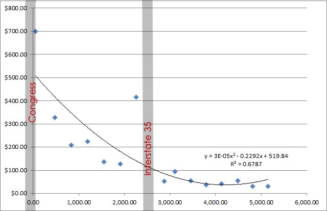
This is some fun stuff. So far this is showing the average of two rows of blocks on the west side of 35 and the 1 set of blocks on the east side that I’ve finished tabulating. The vertical y-value shows Total Value per square foot of land area. The x-axis shows distance from Congress Ave. I’ve also highlighted Congress at 0 and where I-35 falls. As you can see there is a very strong curve present with a solitary spike immediately adjacent to 35. This happens to be due to a hotel that strategically placed itself between highway and convention center.
That’s all well and good, you could take from this info that the highway has no negative value and only positive value since it led to a spike with the hotel development. Perhaps not…
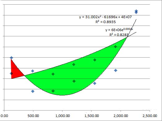
Above is a land value arc over a built value arc (both on the y-axis) with the distance from 35 on the x-axis. This is only on the downtown or west side of 35. The built value is the deep U-shape while land value has a much steadier, more linear effect based on distance, which as you can tell is more affected by proximity to Congress than anything. And by Congress, I’m saying that’s a proxy for “center of town”.
What is interesting here is that, in the red area, is showing the gains which you could attribute to the highway. However, the deep U in comparison to land value’s steady gradient, you might say that the highway is negatively affecting more blocks than it is having positive impact on. I’ll have to dig more into the exact values as I get more block data inputted and tabulated.