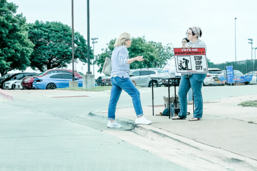
Right now the City of Montreal is undergoing the kind of discordance that I expect more cities on this continent will likely be facing either already or in the future. The infrastructurist has the summation of the battle looming between overlapping government entities representing the competing values of different constituent groups with two eh similar eh sort of different visions but with two totally different goals.


In this case, the City, Montreal, seeks to reduce the size of a freeway in need of reconstruction in order to create room for new neighborhood development lining a new tramway system. The Province of Quebec, says “pas si vite! That plan is too expensive, let’s just build it wider and add more capacity.” The City is looking out for its City, the “state” aka province is looking out for, uh, those that I suppose would be commuting into the City.
On the surface, it is the simple debate of adding more supply to ease traffic vs. reducing demand through the reduction of ease of driving while introducing new modes of transportation. What is missing is the differing effect that highways have on city vs. country. In Montreal’s case, there really isn’t as much to meet the eye as the “battle” suggests. But, the heart of the issue is much more important when we think about Dallas, where the transportation system is designed precisely for “the country” aka the suburbs to get in and out of the City as quickly and easily as possible.
One might say, well that is a good thing, that means commerce. I would say, that those are effectively intracity trips given that the boundaries in the metroplex are arbitrary lines within one economy. So let’s look at the ramifications of such transportation policies.
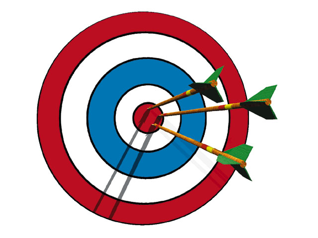
To help us think about this issue, let’s think of the city as a bull’s eye, where the highest value is closest to the center.
The value is highest because there is the most interaction, the most people. In Montreal’s case, it is exactly why people visit Montreal in the first place. Culture, fun, people, amenities, etc. All brought to you at the crossroads of a metropolitan economy, aka a functional downtown. That value is represented loosely by building heights, aka density which is the delivery of supply to meet demand in certain areas.
To add some complexity, the City is actually probably a little bit closer to a bullseye with a dart board overlaid to represent “favored quarters” as Leinberger calls them or the singular direction the upper classes fled cities over the last century, along with the various stages of 20th century building patterns in tow.

The spokes on the dart board are important because they act like the geographically responsive network of roads and natural radial pattern of cities. In the country, aka ‘burbs, highway and arterials work as collectors because of the low density makes no other form of transportation viable and because the low density allows for people to effectively get away from the undesirable qualities of freeways.
However, if you take those spokes into the cities and attempt to make them respond to the similar transportation pattern of only cars, then the roads have to get bigger as they get to the center of the “dartboard.” The spokes of a dartboard do not get wider towards the center, but in cities, and particularly Dallas, they do. If you widen those spokes at the center, you no longer have room for the bull’s eye.
The spokes close to the “bull’s eye” either have to accommodate other forms of transportation, or get smaller and allow for more people place to accommodate the demand to be there.

See downtown Dallas, where the majority of downtown bears the brunt of the tourniquet of car only transportation policy, aka serving the countryside, but not the city. The red area absorbs the negative pressure, which is revealed through the numerous surface parking lots, vacant buildings, and otherwise non-performing structures in terms of tax-base. The blue is the beating pulse of a healthy three- to five-block area of downtown.
As you get closer to the cores of cities, you have more people, more desire, more demand, the roads should get smaller in a more densely interconnected pattern, not larger. This allows for more supply, more choice, more responsiveness to traffic delays, construction, accidents, etc, a smarter neural network of cities. It is more rigid, more resilient, more attractive without the barriers that highways pose preventing the city from ever achieving that demand, aka what we might call city-actualization, if we are to continue the Maslow Hierarchy of needs metaphor.

Because cars and their infrastructure take up much more space than the various other forms of transportation that DO work and cities AND function better with greater density, we end up undermining the very reason people want to be in downtowns in the first place.
See the example of 34th St in Manhattan, where a recent survey showed that more people move by foot than any other form of transit, followed by mass transit, and least of which cars, which between the vehicle and the infrastructure take up the most space. The City has decided to remove cars altogether from the street in order to accommodate, ghasp, more traffic. Why? Cost (and sanity) of course:
To build New York City to a scale that everyone who rides the morning subway into Manhattan’s central business district could now travel (alone, as most do) by car, for example, would require, as was found by one back-of-the-envelope estimation, an additional 76 Brooklyn Bridges.
While we certainly aren’t anywhere near that point yet, this does argue for the shrinking of highways in some locations, the altogether removal in others, and certainly not the widening or adding of additional capacity.
All cities in order to function better economically, socially, and environmentally need to make it more difficult to drive the closer they get to their centers (or multitude of centers for polycentric centies) and easier to get around via various other forms of less consumptive transportation. This means everything at every scale, from more crosswalks, to reduced lanes, to less cloverleaves, less protected left turn lanes, less “flying” right turns, tighter turning radii, etc.
There are solutions appropriate for the country (or State or Province) and their are solutions for the City, but they ARE NOT the same.