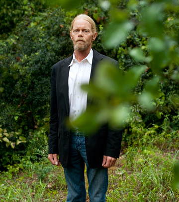

Steve Houser knows trees. Big trees, little trees. Live oaks, cedars, American elms, hackberries. Magnolias. If it has leaves and a trunk, and especially if it grows in North Texas, Houser knows all there is to know: each species’ strengths and weaknesses, typical growth pattern, life span, the best time of year to plant.
Trees have been good to Houser. Tending to them paid for his associate’s degree at Mountain View College. It was only natural that he should eventually make trees his life’s work. Now the blond, ponytailed 51-year-old ringer for William H. Macy is a Certified Arborist and owns a pruning and tree-care company. He also founded the Dallas Historic Tree Coalition.
Trees have been so good to Houser that he felt the need to do something for them in return. Twenty years ago, when Houser’s biggest client asked him to cut down 60 large burr oaks for expediency’s sake rather than any landscaping need, he was forced to make a decision: do what was right for his bank account or do what was right for the trees. Not hard to guess what Houser—who describes himself as “the guy that would stand up and speak for trees”—did. He turned his back on the money and has never regretted the decision.
Which brings us to Houser’s current labor of love. He shows me a video—actually a video of a video. It’s a rough digital image of a tree. The trunk is a brown stick. The leaves are individual green dots. It’s like looking at a bush at night that’s been decorated with Christmas lights; the branches vanish, leaving only the lights and trunk visible.
The image swirls, showing the tree from different angles. Then another tree appears, its Christmas lights a different shade of green. And another, this one smaller. Each tree, it turns out, is real. That is, each image represents an actual tree in Dallas, most likely in Reverchon Park. The different colors represent different species.
If Houser has his way, in the not too distant future, he will have an image for every tree in Dallas. Let that sink in: every single tree in the city.
In 2005, after years of watching Dallas’ greenscape infrastructure suffer under a policy that could best be described as benign negligence, he convinced the City Council to hire its first urban forester. Prior to this, he says, the city expended no effort to plant or even manage the trees it has. The Dallas native is quick to point out that other cities were way ahead of us on their arboreal management, his tone as prickly as a bouquet of pine needles.
“Fort Worth has had a forestry program since 1929,” he says. In fact, nearly all big cities except Dallas had some sort of tree program.
The hiring of a forester was only a first step. Houser went on to convince then Mayor Laura Miller to establish a Dallas Urban Forestry Advisory Committee, an attempt to catch up with the rest of the nation’s metro areas in caring for our green infrastructure.
The first step of any program of this sort is logical, though daunting: figure out the numbers. How many trees stand in the city of Dallas? The approach taken by every other urban forestry program has been decidedly low-tech, a physical count: numbers, species, size, that sort of thing. They use wood—paper, pencils—to count wood. That wasn’t good enough for Houser, an inquisitive type who soon uncovered a technology called Light Detection and Ranging, LiDAR for short.
LiDAR, simply put, uses light to measure objects. Think of it as radar, only instead of radio waves, light is used, specifically lasers. Aim the LiDAR machine, firing a beam of light every few milliseconds, at an object, and it creates a fairly accurate digital image of the target.
There was only one problem. Nobody had ever used LiDAR to inventory a forest. Seems there are some technical hurdles when it comes to imaging individual trees: canopy coverage, inability to differentiate between species, false positives from shrubs, and so on.
Houser kept looking around and eventually struck on another technique, hyperspectral analysis. In layman’s terms, hyperspectral analysis processes energy—“sees it”—from across spectral bands of color. Think of it this way: people see colors, wavelengths of light that make up only a narrow sliver of the entire color spectrum. Hyperspectral analysis sees colors and then some, the energy on either side of visible light.
Houser’s big idea: what if someone combined LiDAR, lasers bouncing off stuff, with hyperspectral analysis, what the colors meant that bounced back?
The problem was that only a handful of people in the country were working with hyperspectral analysis, and none, as far as Houser could tell, had written the sophisticated algorithms needed for a computer to figure out what different trees “looked” like. Houser found his way to Dr. Fang Qiu, who, as luck would have it, was an associate professor of geospatial information sciences and remote sensing at UT Dallas. He was one of the few experts in the nascent field.
The two men came up with a plan. Houser and Qiu set out to collect the energy signatures of the 50 most common tree species in the area. The idea was to create a library of archetypes. This is what LiDAR and hyperspectral analysis say a pecan tree looks like. This is what a mulberry tree looks like. As you might imagine, in a city where concrete is king and discussions about trees tend to revolve around those of the artificial Christmas variety, Houser had a tough time getting the City Council or even the members of the Urban Forestry Advisory Committee to fund this initial step. Or even to understand it.
No matter. With money from his own pocket and an enthusiastic partner in Qiu, Houser climbed into trees and began taking pictures. But that was only the start. After Qiu analyzed the initial data, writing sample algorithms and proving this new application of two technologies could work, the men were faced with a large assignment: the actual inventory.
Houser decided to start small, imaging the trees in a 20-square-mile slice of the city, a gerrymandered swath stretching from Reverchon Park to White Rock Lake, the odd shape due to Love Field flight safety issues. For this task, a little more was needed than a bucket ladder and a can-do attitude. Things such as a specialized aircraft that was capable of accommodating the LiDAR and hyperspectral analysis machinery, and time on a supercomputer to crunch the ocean of raw data.
City staff was enthusiastic until they got an estimate for the work, a rather stout $140,000. That was cheaper than a physical count, but it was still a big chunk of change, even in those pre-crash days only two years ago. So Houser raised the money himself, getting donations from friends and clients, and several grants.
The results are in, 200 gigabytes of data on Qiu’s hard drives. A final analysis is due any day now. If all goes as planned, Houser hopes to persuade Dallas and other area municipalities to fund a larger inventory—like, say, of the entire region. Possible uses for a broader study are endless. “This can be used for green, gray, and blue infrastructure management,” Houser says. Think storm water control, soil erosion issues, even how and when it’s best to prune a given area.
And there’s one more possible use. Interspersed with all the Christmas lights are angular areas of gray, representing buildings. The Dallas Code Compliance division is excited about the prospect of seeing beneath the tree canopy and possibly spotting un-permitted construction.
Write to [email protected] .