I’ve been beating the drum lately on what exactly is the purpose of our road network? What is the purpose of our city? The city is a system with a purpose to serve human need and the movement infrastructure is a subsystem that must be subservient to the larger need. Instead, we build for “growth” rather than any real purpose, say, like say safety, security, and social/economic economic exchange.
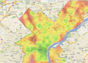
Let’s unpack some of these with the help of a few graphics I’ve used in the past and one new one. First, we look at Philadelphia and a the correlation between crime and highway locations:
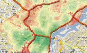
Red is higher crime areas per capita, green lower. Other than 676 the Vine Street Expressway, red areas line up with the freeways. Crime often occurs more often in the dark and is more comfortable occurring in places where people aren’t, disconnected places. The Vine Street Expressway is sunken and the grid remains intact. Not ideal, but better than the alternative.
Now, we look at a comparison in walkscore heat maps of Philadelphia and Dallas:
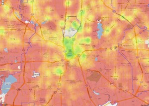
Again, red bad green good, that is if you assume not having to own a car to participate in the local economy is a good thing. I obviously do. Why force people into upwards of 40% of their income dedicated to transportation? In these situations, attempting to make transit work is rather desperate and service is always less convenient than the car, since the entire city framework is built solely for car use.
Next we have a look at downtown Dallas where I mapped outdoor cafe seating mashed up with what I deemed to be overly large radii, the curvature of roads and off-ramps meant for “efficiency” of car movement, ie not to stop or slow cars:
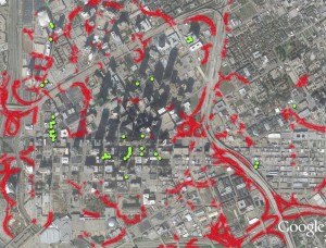
Rarely do cafe seats occur within proximity of high speed traffic, it is simply uncomfortable and undesirable to do so. Of this map, it should be noted that many of these aren’t doing so well and aren’t often populated, with the exception of the most interconnected and slowest speed traffic areas of the Main Street core.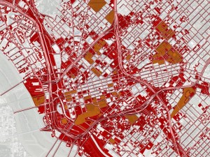
Next is safety. Here is a map cropped of the immediate downtown area showing where traffic fatalities have occurred between 2001-2009: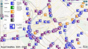
Blue is pedestrian, purple is vehicle occupant. As you see, the most align with the freeways. Isn’t the first role of public governance to keep people safe? Or building roads they can’t maintain?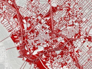
Here is a map I made 4 or 5-years ago showing the relationship of highways with “underdevelopment,” which is vacant land and surface parking lots:
Fairly striking. And we’re told that road widening is for economic development and growth. Only that economic development occurs primarily outside of Dallas proper so the city gets none of the benefits and all of the burden. The other issue is that the growth likely would have occurred anyway, except in this format cannibalizes from Dallas and feeds places like Useless, Farland, and Farlington*.
*Not real names. And no offense intended towards those places, but in order to survive the 21st Century, they will have to reposition themselves as more autonomous and less dependent.
Now let’s add in tax exempt entities and properties on top of the last graphic:
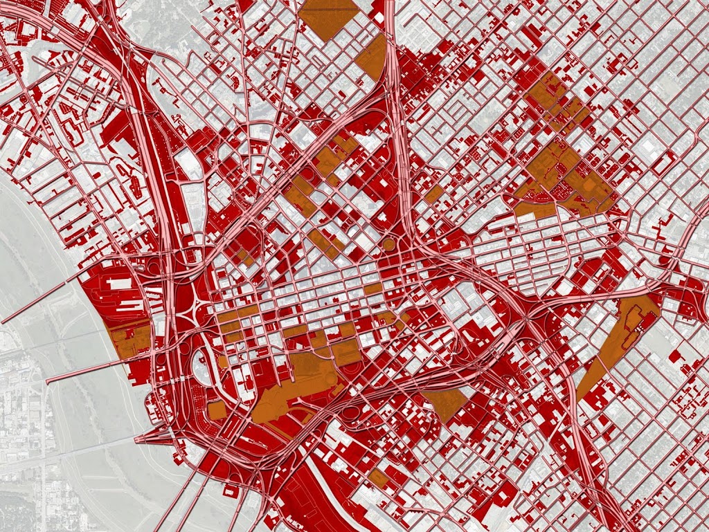
Orange are those properties which consist of city and federal buildings, churches, schools, some parks, and some transit-related facilities. Many of these add real value. But the larger point is that they are situated on land the market deems not terribly suitable for anything above surface parking. Such is the highest and best use of freeway adjacent land. Land is cheap and wouldn’t generate much tax revenue anyway so on goes an [insert magic bullet of revitalization].
And lastly, our study area for highway segment removal, IH-345 between downtown and Deep Ellum:
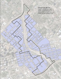
This is 245 acres of downtown and downtown adjacent land that generates all of $3.5 million in tax revenue per year for the city. By removing the freeway, we could create more than 60 acres of developable land that was public right-of-way AND reposition 120+ acres of underdeveloped land.
Our most CONSERVATIVE estimate (which is preposterously conservative in terms of proposed development density and future land value – 1-story buildings and land value remains stagnant) adds 6x the amount of tax revenue per year and IIRC about $750M in new investment. Our more ambitious numbers approach $100 million in tax revenue per year and $6 billion in total investment. All by removing a liability and restitching the grid. Expect our full report and proposal with all sourcing, metrics, and methodology within the next few weeks.