I want to take a graphic look at some concepts I’ve been developing lately, in conjunction of course with the work it builds upon, including the Bartlett School at the University College of London and their work on mathematical models of spatial integration as well as the Andres and Douglas Duany codeveloped concept of the transect.
Spatial integration began as a scientific examination searching for objective realities to urbanism. Why were cities and their patterns so similar? Where and when have we begun to go wrong? And is the aesthetic, subjective driven world of Modernist architecture partially to blame?
Completely independent of this work, the Duany brothers saw similarities in the gradient of intensification of cities as you got closer to the core with various ecologies, particularly coastal regions:

This, became this:
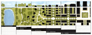
Both relied, perhaps intuitively on the concept of centrality, which has its origins in the study of social networks. Since cities are the physical platform for social and economic exchange, empowering the links between them, network studies had direct relevance. Cities are networks.
But the Transect never really digs into why what was where. Sure there is a dense node at the center, with an decreasing gradient the further you get away from it. But what created centers in the first place? That is where space syntax began examining infrastructural networks. Professor Bill Hillier and his pupils/colleagues found a correlation between social network analysis and infrastructural networks. That is, social hubs have the most connections. The highest degree of integration. Likewise, this parallels with the internet. The highest trafficked sites are hubs that all others link to. Think Google. From there exists a hierarchy from most to least.
Likewise, cities have a similar hierarchy. The most connected places, have the highest degree of integration, which in turn means the highest degree of opportunity. Where there exists the greatest demand, to which the market responds with supply. Building space. Where demand is greater than supply exists the most opportunity for developers. Where integration is highest is the most opportunity for every citizen to meet their needs for social and economic exchange.
This concept exists locally, within one city, as well as globally, amongst all cities. New York, London, Tokyo, Paris, etc., are global cities because they are the most connected, both locally and globally. Within a single city, you also have a hierarchy of centers. All cities are polycentric once they get above the scale of the tiniest of hamlets. This is what sprawl apologist hacks like Joel Kotkin fail to understand. When they talk of polycentric, sprawl-based cities as polycentric cities of the future, they fail to see that New York is also polycentric. Those centers just blur together rather seamlessly, except where geographic barriers (water bodies) or physical barriers (such as highways) divide and isolate them.
Space Syntax map of London:

What they found was that there is a correlation between traffic and value. Just like with any network, particularly the web. The most trafficked sites have the most value. Remember that traffic doesn’t mean cars, but people. This is a direct relationship in what I call logical cities. High pedestrian areas have far more people moving past, and capable of interacting with you (economically or socially) in these high traffic areas than does car-based traffic, which has to turn, wait for lights, find parking, etc., all of which accounts for increasing degrees of disconnection, dislocation, and inflexibility.
In the logical city, such as the London-based map above, there is another chicken/egg based component to it as with all complex, interconnected systems. The infrastructure funnels traffic to specific places and specific places also “bend” the infrastructure to them. This is why I call them centers of gravity, what many planner types call “nodes”. They literally shape the city around them. Increasing their level of interconnectivity, raising demand, and eventually via opportunity, supply.
Because of the chicken/egg scenario, this also means that infrastructure can create places out of thin air, such as when two railroads meet in the midwest. The traffic intersection becomes an opportunity. And many cities are here today because of such a phenomenon. I’ll look at that a little more later.
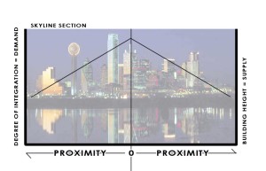
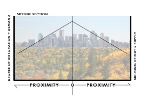
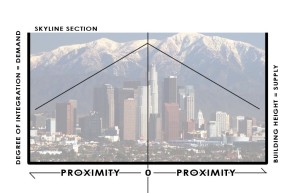
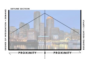
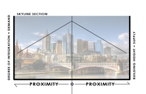
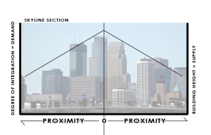
But first, here are several skylines:
While this is Dallas and the exercise is admittedly abstract, I want to show why downtowns have the biggest buildings. And why severing the interconnectivity to them, is why many of Dallas’s buildings in downtown are quite empty, for example. As I have written before, Dallas experienced a building boom (high-rises) at the exact same time that the city, state, and federal level were gorging on highway building. Supply was being added while demand was being undercut, shipped out towards the suburbs.
Those polycenters, instead of being closely interconnected, became Las Colinas and the various highway adjacent corporate office parks around the metroplex. That they were newer or the space is better and they are “grade A” office is irrelevant. The newer development would be in and around more walkable, more highly integrated and interconnected places (more authentic places). They would also prove to be more resilient. I expect, unless they drastically reposition themselves, many of these office parks will fade into dust. With new light rail (another degree of interconnection) and residential, Las Colinas is already doing that.
Compare our growth to say, L’Eixample neighborhoods in Barcelona and Valencia. These were rapidly expanding areas, literally doubling city size, but they did so aggregately. These are both now considered the “old money” areas of those particular cities, and very much still central city as growth then enveloped them.
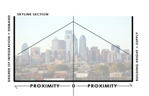


The dynamic changes a bit for cities like Paris or Washington, D.C. Both cities with extremely high levels of integration, locally and globally. Remember, that local integration is the foundation from which density and resilience lie upon. The most connections can be made locally in dense, walkable environments.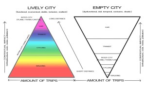

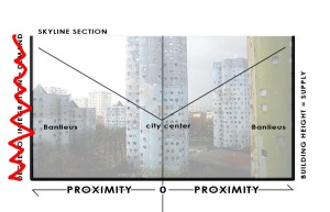
Because the level of integration is so, demand is extremely high to be in the center of Paris (or D.C.). But height restrictions limit the amount of supply of usable building space, making prices skyrocket. The center of Paris is amazing. Who doesn’t love it? But it also leads to this condition where opportunity then shifts outward, toward the Banlieus, or suburbs:
The supply is much greater than the demand, which is to be actually in Paris where opportunity is high. But it the market can’t meet the demand, so it spills outward. Too much supply, with too low levels of integration. There isn’t a natural, organic match. This is made even worse with the design of the “towers in the park” housing for the poor. Whether they were built for the poor or not, eventually they were doomed to devolve because of supply being much greater than the demand. These types of Corbusien buildings are physically isolating, cul-de-sacs in the sky. In effect, the supply is borrowed from the areas with higher integration, higher value. Not coincidentally, these are the areas where Paris experiences the most civil unrest, in homogenous areas of poverty exemplified by socio-economic isolation. Isolation. As in not integrated.
However, this is not to say whether Paris or DC’s restriction on building height is wrong. That is a political debate. In my estimation, these cities heights or lackthereof is precisely what makes them so special. 1) The building heights remain humane, lower to the street level, and more interactive. And perhaps more importantly, 2) the demand pressure exerted upon a limited supply ensures that the limited space will always, ALWAYS be maximized. And buildings will be preserved rather than destroyed.
The real issue is improving the connectivity, integration, and walkability within and to the suburbs. Here is where I shift in language from banlieus to suburbs because the need is universal. American suburbs may not have many, if any, high-rises, but supply is currently way above demand, as defined by spatial integration values. Values are plummeting across the country, not only because of the evaporation of liquidity (real or imagined), but also a general market realization and price correction towards this supply/demand imbalance.
There is a movement afoot to “retrofit suburbs.” While there is certainly opportunity to do this, and a necessity in many cases. I’m afraid that while some areas will be fine, some will need salvaging, while others are fairly doomed. We simply won’t have the capability of retrofitting ALL of them. And by retrofitting, I mean increasing their local connectivity/integration quotient to instill, increase the demand to catalyze the new infill that the retrofitters propose. There will be extreme levels of competition and upheaval, I expect, in American suburbs.
As for city growth:
As I mentioned earlier, it all starts with an intersection. This could be anything:
Two railroads crossing
Two ancient trade routes
Fertile soil and a deep water port
The connection globally has to be strong enough to maintain the raison d’etre. The local connections, like walkability, ensure that the place is efficient and livable. And that people like living there as opposed to the competitors. It is also important to note that no cities current place within the hierarchy is the place it will reside in 10-, 20-, 50-, or 1000-years. Such is the competition amongst cities. And such is the need to maximize local and global connectivity, as well as the raison d’etre for that city, whether it be energy production, idea production, or a socially vibrant place. Whatever it is, it better be timeless. See: Detroit, autos. West Texas, exhausted oil wells. Heterogeny ensures timelessness. Or something approaching it.
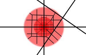
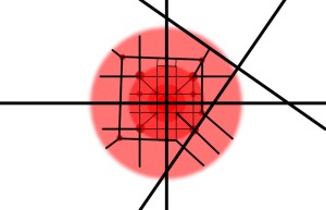
Here is the intersection. Imagine it is any of the aforementioned. The red implies the neighborhood development.
If the raison d’etre is strong enough, its opportunity level persists. It attracts more people. The city expands, aggregates:
Eventually, maybe it grows to the point where it needs more global connections. And as technology advances, the infrastructure is needed for those global connections, such as an airport and an interstate. However, all global movement is destructive to fragile local interconnections. Highways and airports can have negative effects upon overall interconnectivity despite increasing global connectivity. Local connectivity drops, therefore demand drops, therefore desirability and opportunity drop and eventually people will leave that city. That is why these global infrastructural networks must be treated very carefully, connecting with cities tangentially.
Vancouver didn’t allow freeways into their city. Paris is removing all of them inside the peripherique. They’re connected to their airports via subway. Subways are built because at-grade and above grade tracks are disconnective. Below grade is supremely expensive, but as all cities who have them have found, worth the high initial cost to preserve the fabric above.
And within those overall connections, smaller nodes or centers of gravity will emerge at the various convergence points. That is, only in the logical city. In the illogical city, where connections are disruptive and diminish overall connectivity and the ability of its citizens to meet their social and economic needs for exchange, a tension is created. The tension is two countervailing forces. That towards traffic, ie traffic = value. And the opposite force is the repulsive nature of those global connections, ie highways and airports.
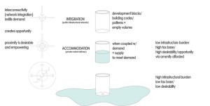
You may have to click on the below image to expand it. It’s one I’ve been working on to explain this concept. At the top left we have attractive nature of convergence. People create infrastructure to create opportunities for social and economic exchange, meeting points, trading places, markets. When you disrupt that network, you shift the magnetism so to speak, like putting two like poles of magnets next two each other.
When you look to the right diagram, the glass is supply of building form. The demand is liquid. When you interrupt local connectivity and overall integration (often for the sake of global connectivity), you are essentially creating a hole in the glass. All of the demand spills outward. You get sprawl and an empty glass. Like downtown Dallas highrises.
Get the D Brief Newsletter
Dallas’ most important news stories of the week, delivered to your inbox each Sunday.
