This post begins with the assumption, which I would call observed fact, that all development is a direct response to the primary mode of transportation serving the site (primary mode can also include multi-modal). When specifically applying a mode of transportation and accommodating it on a site, this assumption makes logical sense. It is the single most important determinant
For example, if everybody is travelling by car, the parking necessary takes up valuable FAR. Similarly, ports/docks are low density b/c everybody is on a boat b!tch. People arriving via transit are all on foot, pedestrians are on foot, and don’t exactly need a place to put their shoes. And if they did, the foot lockers wouldn’t exactly take up much space. That extra room for parking is either immediate for access (ie in front) or hidden to ameliorate the effect parking has on a building’s ability to engage the public realm and participate in the multiplier effect of the “urban buzz.”

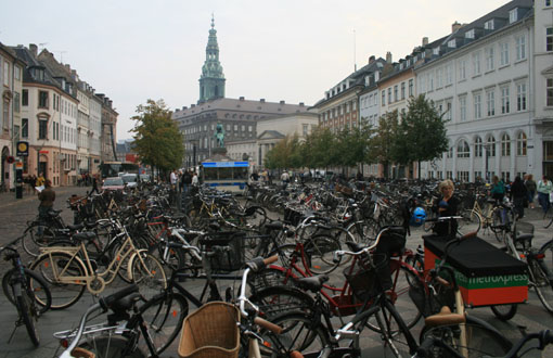
Copenhagen bike parking, compact and not sociofugal like a car park.
The two solutions are various shades of bad: very bad and less bad, because as I said it takes up valuable building/leasable space and it disconnects a building from its context thereby turning the building into a “non-sequitur” building, meaning it does not participate in the synergies that create a whole that is greater than the sum of the parts. Furthermore, the parking provision (and in cities where land and development is more expensive) has become a barrier to development, often accounting for upwards of 20% of a project cost.
To further the linguistic metaphor, in syntax, there are certain rules for things to come together to make sense (in cities these would be livable places). Once the rules are satisfied art can be applied to create poetry or prose and invoke even greater meaning. In cities, these become lovable places.
We obviously can’t just start building without parking, as everybody (but me) is still stuck in a car on the road. But, we can alter the transportation network that informs the development density (and quality). I don’t mean removing roads altogether, but slowly and incrementally ratcheting down the scale of many of the roads in the city and pinpointing any road designs that negatively affect urban tissue, creating places less than the sum of the parts.
Dallas is in the top five in the country in constructed freeway miles per capita. Extrapolated, it is probably pretty safe to assume that American cities dominate in the world list for this statistic as well, meaning that D/FW has nearly as many freeway miles per capita as any city in the world. Top Five WooHoo! Time to celebrate? No sir. And we’re gonna drive from Dallas to Darmstadt, Germany to see how much money we’re wasting.
—————————
As I posted the other day, Prof. Bill Hillier discussed development density, how it is created and defined by the density of the local grid network. The combination of the two components combine to create “urban buzz,” or as I would describe as the facilitation of synergistic economic activity.
Obviously, economic factors have to exist to have demand for population to be there in the first place, the grid is then the application of a platform for increasing economic activity. The economic purpose makes for a VIABLE city. The grid allows for a LIVABLE CITY. And, as I said earlier, applying CIVIC ART then creates for MEMORABLE or LOVABLE cities.
You can’t just start laying out a grid in the middle of nowhere and expect “urban buzz,” but that won’t stop people from trying apparently:
The visual mind virus of Bizarro Keynesian Meme. Build roads, expect development = stupid supply side urban development, rather than incrementally allowing demand for new development and expansion of the grid to accommodate it. This is what we mean by not overextending yourself financially by way of infrastructure.
Looking further into why Cities have roads and what purpose they serve, Hillier also talks of the necessity of local and global connections. Let me refine this dichotomy to include a greater range of: local, city, metropolitan, regional, global. Extracting Jane Jacobs, highways are essentially global connections b/c they link global hubs ie airports to cities (as macro destination), as well as cities to cities – for example Houston area to Dallas area. The grid then allows the connections from microdestination to microdestination, or intermideate destination (such as a transpo hub) to microdestination (your house, your job, third places, etc.). As Hillier suggests, the local grid connects everywhere to everywhere and allows the necessary flexibility of choice to get there without all traffic funneled to overly hierarchical dendritic arterial systems.
So we have our five road “connections, which I’ll number by intensity or volume:
1. Local
2. City
3. Metropolitan
4. Regional
5. Global
Each of these connective “purposes” has an appropriate design solution that either can engender high quality, dense urban development or do just the opposite. This post will show examples of both.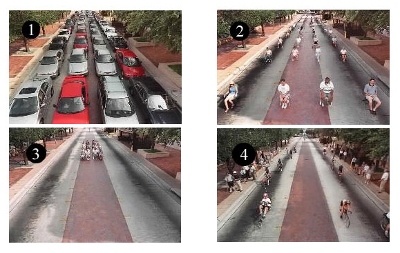
Oft repeated schematic illustrating spatial relationship and densities of people by mode of transpo. As you can see accommodating modes other than cars allows for greater capacity. Moving greater capacity is supposed to be any transpo engineers job. Greater capacity moving by a site, equates to a higher “highest and best use,” meaning more predictably successful commercial enterprises, more “urban buzz.” Oh, and as we’ll see, it just looks nicer, feels nicer.
Looking specifically at Dallas, anyone that approaches downtown from the North via the Dallas Tollway arrives into the City experiencing a descension of hierarchy from road type 5 all the way down to 1. This is what we mean when we say context sensitive design. The street capacity is reduced as the road descends further into the City. However, as we’ll see, Context Sensitive Design can be poorly sensitive or misinterpreted as the roads are all poorly designed, strictly for the maximum amount of cars and little else (like a DART bus or two) meaning not operating to full capacity as the picture above shows.

This entry experience will follow a 2-mile stretch of roadway as the Tollway as it merges with and becomes Harry Hines, until it turns into Akard St. until it terminates at AT&T and Golden Boy!

Category 5 (failed autocentric version): Characterized by flyovers, overpasses, cloverleafs, and related over-engineering. Notice that no development wants to engage with roads like this in any way and some futile attempts to “green” it up is made to make it barely palatable, ie more sunk costs.

Category 4 (failed autocentric version): I believe we are near Harry Hines and Wolf here. The street now has traffic lights, six! lanes (all each too wide as well), and a pointless sidewalk right up to the curb. Often has surface parking in front to provide “access” and the only thing noticeable is a KERA billboard for drivers b/c nobody is expected to be on this road on foot. You’ll also note that this is one-way here, meaning it has a mirrored overly wide, poorly design street running parallel one block to the East.

Category 3 (failed autocentric version): It’s actually two-way with some on-street parking here, yet it isn’t exactly helping business, except that we’re greeted by a porte cochere and two curb cuts. Prime example of a building relating to the form of transportation. You’re obviously arriving by car, we’ll design our entry to greet cars. Oh, and a blank wall.

Category 2 (failed autocentric version): Back to one-way. Apparently, we have yet to learn that businesses need two-way streets to maximize predictable visibility and locational choices. As we said earlier, commercial success (and urban buzz) requires as many people moving by as possible (a focusing of the energy of human movement). Two-ways is better than one. Also, on-street parking is available at points along this street but it is spotty. We see another covered porte cochere and a sidewalk with no buffer from moving vehicles.

Category 1 (failed autocentric version): Given that this is at the intersection of Main Street (the one area of successful urbanism in downtown) and the Harry Hines/Tollway funnel, this should one of the most important and successful streets in Dallas. Main Street works, but as of yet, the “buzz” hasn’t spilled southward toward the poor, imprisoned Golden Boy. This is partially due to the design of the street which doesn’t convey its importance (and I don’t mean widening). It feels like a back alley.
So what have these roads bought us? Well, because they are design to be sociofugal (and repel people), they become escape routes. As I suggested earlier this week, countering the argument that big roads deliver people to a city, it’s a zero-sum game in terms of people coming and going on those roads, but when you factor in what they have done to the real estate, the extra cost of widened (virtually) car-only roads has decimated real estate development and urban density.
The density WE DO have is designed to be entirely auto-centric as well, with large parking garages as well as front doors that are little more than car drop-offs/porte cocheres.

The street edge is even defined by walls. agggh, more tree lawns!!! kill me!!!!
Furthermore, all of this high-rise residential/condominium development dotting lower McKinney is entirely a by-product of the falsely created, irrational housing exuberance of the past ten years. If it had to do with actual demand (one, it would be filled), it wouldn’t be so poorly designed in how it engages the public realm.
So what are examples of roads that these should look like? Well, I’m glad you asked.
A better #5 – limited to the outskirts of the city. Very few $750 Million overpasses/interchanges, because highway to highway interaction is rarely four-way and they don’t intersect every two miles. Lined mostly by natural buffers, development is rare except at the highway to boulevard hubs. There are no frontage roads, which bleed the “movement economy” energy from the lower level streets, which can better accommodate development.


A better #4 – ignore that this is the Champs Elysees which acts as a “main street” of Paris. 4’s should be the primary vehicle traffic movers of any metropolitan region and can accommodate development directly interfacing with and benefitting from the energy moving by on the street because of the buffers created by the allees of trees, a browsing/parking parallel “slip” lane, and ample sidewalks. These streets still require a development coding maintaining a linear street wall to maximize use to use adjacency/synergy.

A better #3 – a lesser version, or lower scaled “complete street” from #4.


A better #2 – Main Street in downtown Dallas would be a good number 2. However, I would categorize it in the Dallas hierarchy as a 1, the lowest capacity because the road hierarchy is on steroids. The theme of this post is that in Dallas, all of the roads, need to go on “road diets” and scale from bad 2’s to good 1’s. Bad 4’s to good 3’s.

A better #1 – Rather than alleys, we start using terms like woonerf or mews. Examples include Stroget (the carfree area in Copenhagen) or even the small side streets with cars near Stroget that will probably go carfree soon anyway. Point being, cars can still get through as you see above, but it’s primarily only delivery vehicles. Who else would want to try to drive through there? Curbs aren’t necessary b/c bikes, pedestrians, strollers, pedicabs, you name it all have equal right-of-way to the space. This is the epitome of street as space.
So what does all of this mean for Dallas? Dude, you’re full of something, not sure if it’s questions.
I thought we were driving to Darmstadt. Are we there yet?

Yes. This is Darmstadt, Germany. When placed over Dallas at a similar scale, we get this:

Darmstadt is a city of 142,000 people. The orange shows all of Darmstadt minus the “boroughs” of Eberstadt, Arheilgen, and Wixhausen (all compact suburban satellites off the map, but still within city proper) taking the total population of the orange area down to approximately 100,000.
It should be noted that Darmstadt also barely has any buildings over ten stories, other than the middle finger building (shown below), of course. Most of which are steeples or various other associated vertical elements with civic/cultural edifices.

I wonder where or towards whom it is facing? Probably Munchen.
While not entirely accurate, the orange area covers the equivalent of Dallas zip codes 75201, 75202 (downtown) and 75204 (uptown), meaning we’re probably looking at a max residential population of about 25,000, or one-fourth of Darmstadt’s density.
As you can see from the aerial, its compact nature allows for preservation of nearby agricultural land for food production as well as natural forests/habitat. The freeways are all exterior to the actual city preventing them from having the corrosive, deleterious effect upon the urban fabric which we know all too well. The city is then accessed by roads lower on the hierarchy.
If as the saying goes, “density buys amenity,” apparently in Dallas we just buy entirely too much car infrastructure which means that much less in the way of amenity and livability.
P.S. I have a much more in depth post looking at Darmstadt that has been about half-way done for about a year. I’ll try to get that finished within the next week.