Last Updated, 2/2, 7 a.m.
Good morning. Welcome to the fourth day of Winter Storm Mara, which dumped another blast of freezing rain on much of the metro area while you were sleeping. Temperatures are just about freezing and will creep up to 37 degrees today, which leaves the National Weather Service skeptical of much improvement on the roads until the sun comes out tomorrow.
The high on Friday will be 48, which will help thaw out the roads. The NWS believes we could see the accumulation of .1 of an inch of ice again today; the chance of rain is at 60 percent. Wednesday’s story is below. We’ll have a separate Thursday update later today.
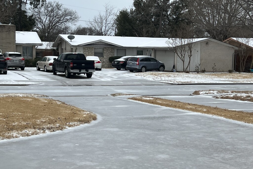
It’s still cold, and it looks like that won’t change anytime soon, which means that you are probably still looking out at a solid sheet of ice on your street.
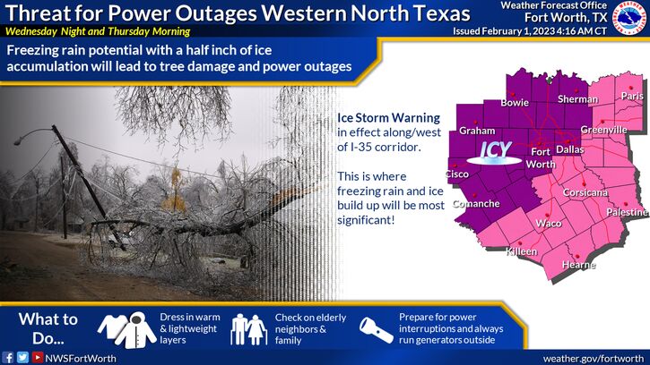
The National Weather Service said early Wednesday morning that it revised its Ice Storm Warning to include Dallas County, after initially issuing it only for North Texas counties to the west of I-35W Tuesday night. Dallas is at risk of accumulating around half an inch of ice between Wednesday afternoon and early Thursday.
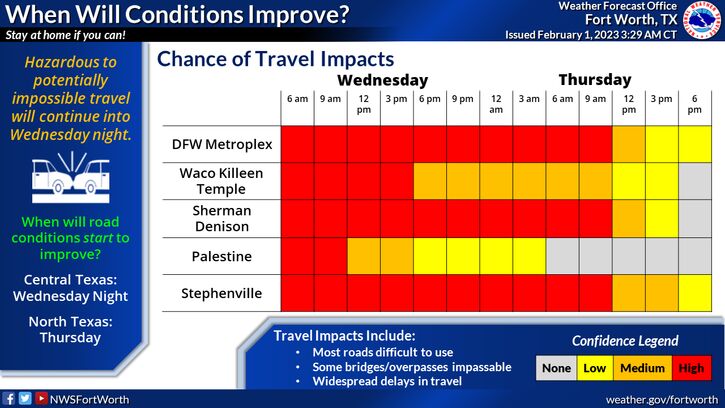
Forecasts for North Texas show that temperatures will not climb above freezing until Thursday. Freezing rain and regular old precipitation is expected to last off and on all day and evening. By Thursday morning, that precipitation will likely switch to rain only, and—good news—the high will reach the mid-30s, and remain above freezing all day. The NWS warned Wednesday morning that the packed ice on the roads would likely last through Thursday.
The Texas Department of Transportation’s road condition map shows all of the highways in North Texas covered in ice. Crews continue to treat the roads, but with more precipitation expected and temperatures expected to stay well below freezing overnight, conditions will likely be dangerous Thursday morning.
“Current radar is showing rain across the region with temperatures in the upper 20s… not great,” the NWS tweeted around 3:30 Wednesday. “Freezing is 32F. The sun sets at 6:02 PM tonight. Road conditions will be AWFUL after sunset and overnight. The freezing rain will continue.”
The Plano Police Department warned Wednesday morning that roadways were “nearly impassible,” and asked motorists to avoid traveling “for any non-essential purpose.”
The additional ice rolling in also increases the likelihood of localized power outages, since it can bring down power lines and tree limbs as it accumulates. The Electric Reliability Council of Texas grid dashboard still indicates that the state’s power generators are keeping up with demand, but Oncor’s outage map Wednesday evening indicated that 2,709 outages had been reported statewide, with a little more than 102,324 customers affected. The majority of those outages are occurring in East Texas and around Waco.
Outages in the Dallas-Fort Worth metro area are nowhere near as significant as they are in Austin, where more than 170,000 Austin Energy customers have lost power due to local outages caused by, among other things, tree limbs falling into power lines.
The road conditions and frigid temperatures have also caused some services to be paused. Dallas announced Tuesday that trash pickup was canceled during the winter weather, and the U.S. Postal Service temporarily suspended operations in North Texas Post offices Tuesday. (It added that letter carriers would make “every effort” to deliver mail Wednesday.) Dallas also closed all of its libraries, with the exception of the J. Erik Jonsson Central Library, which is operating as a warming shelter.
The city’s inclement weather stations are open, as are the Salvation Army’s warming stations in North Texas. A statewide list of warming stations is being maintained by the Texas Department of Emergency Management.
Dallas Area Rapid Transit is still running its standard service for bus and rail, but has reported “significant” delays, and is advising riders to plan for longer travel times. Paratransit service has been canceled with the exception of some medically-necessary trips, as are most shuttles (with the exception of shuttles near UT Southwestern Medical Center). It will also keep its DART transit centers and stations open from 5 a.m. to 10 p.m. to allow riders to stay warm. The streetcar between Oak Cliff and downtown is not operating.
All local schools either canceled or are offering classes remotely Wednesday, and by 4 p.m., pretty much every school in North Texas had announced they would also be closed Thursday.
Air travelers are advised to check with their airlines before heading to the airport; hundreds of cancelations have stacked up at both Dallas-Fort Worth International Airport and Dallas Love Field. Around 4 p.m., almost 80 percent of flights at DFW Airport and roughly 70 percent of flights at Dallas Love Field had been canceled, according to FlightAware.
Author