Winter is here, all at once. The National Weather Service anticipates “exceptionally cold” temperatures through Monday. On Saturday night, arctic air from the Rocky Mountains arrives, plunging temperatures to as low as 5 degrees on Monday morning.
The winter storm warning that was in place since last week has expired, replaced with a wind chill warning that advises Texans to stay inside.
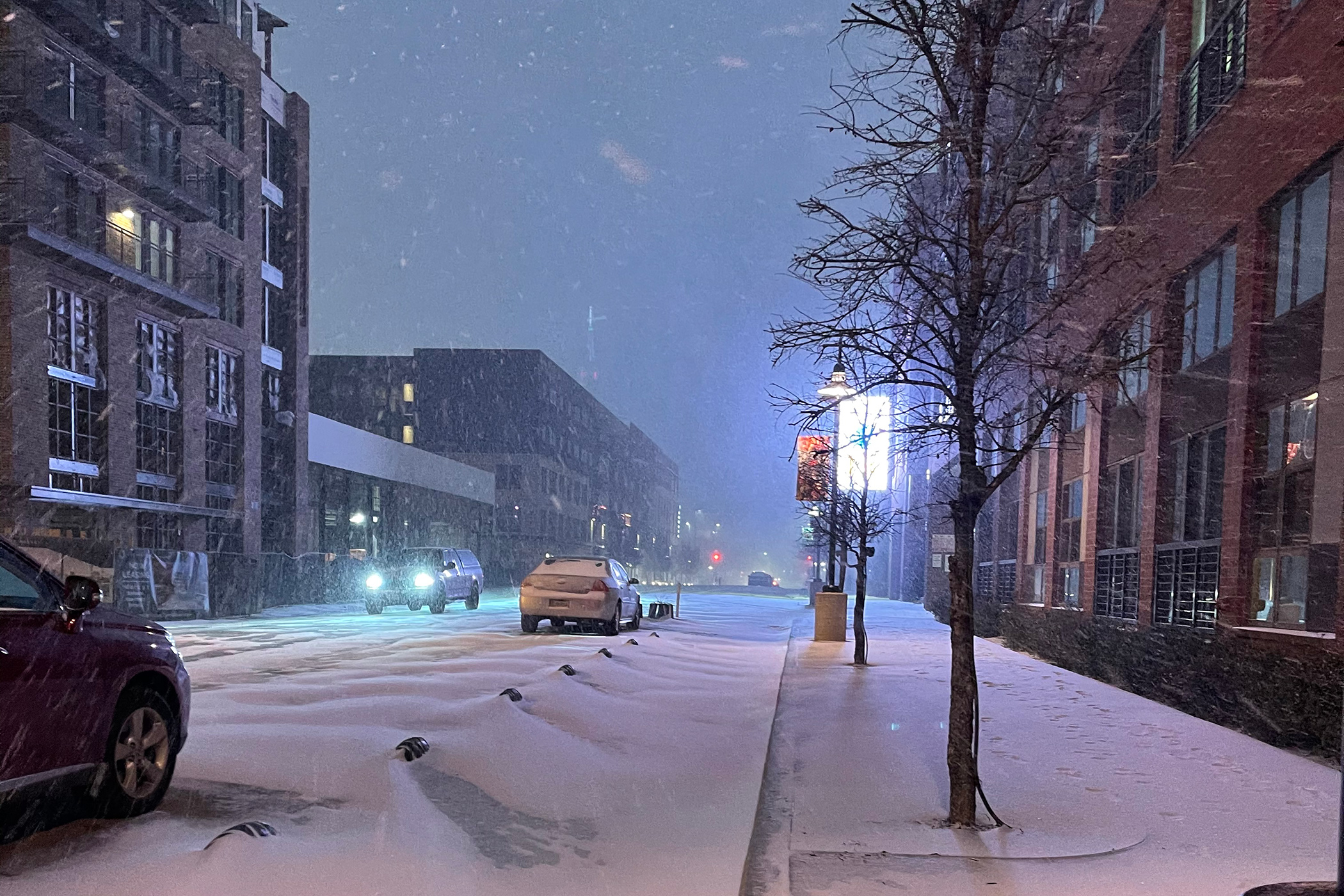
Saturday afternoon will be the last time we see temperatures above freezing until Friday. Sunday spent its time in the 20s and teens, with wind chill flirting around zero. We got about four inches throughout the day and night.
Monday’s low hovers around the low single digits. Wind chill will be below 0 through Tuesday. The snow returns on Tuesday night and Wednesday morning. Temperatures will be so low that the National Weather Service is warning “major stress on the region’s infrastructure” and says anyone stuck outside for prolonged periods of time is at serious risk of death. And, indeed, more than 1 million Dallasites face other outages.
Head below for the latest.
This will be updated as needed. The last update came on Monday, Feb. 15, at 12:20 p.m. Conserve energy and stay inside.
Latest Updates
Here is what we’re facing now: wind chill of about -15 degrees and a historic strain on our electric grid. The snow fell most of Sunday afternoon into the evening as a large, slow-moving band covered most of North Texas. No more snow is expected on Monday, but officials now have to face the ramifications of the last two days.
In a statement, Gov. Gret Abbott said some generation facilities froze overnight and are currently unable to produce power.
According to Oncor, more than 1.1 million people in Dallas-Fort Worth have lost power. The Electric Reliability Council of Texas, which manages the state’s electric grid, said it was requesting Oncor and other utilities to issue “controlled outages,” which could last hours.
This storm is also damaging infrastructure. Sarah Barnes, a meteorologist at the National Weather Service, said the freezing temperatures can cause ice to build up on power lines and trees. That’s not going anywhere. If your power remains out past an hour, report it to Oncor. It could be a bigger problem than conservation efforts.
“Due to the severity of the electric generation shortfall, our expected outage length of 15 to 45 minutes has been significantly extended. Outages due to this electric emergency could last for hours & we ask you to be prepared,” read a statement from the energy company.
The National Weather Service has issued a wind chill warning for basically all points north of Austin up to the Oklahoma border. That lasts through Tuesday at noon, replacing the winter storm warning that had been in place since Friday. The cold, which can reach negative 20 in some parts of the state, can cause frostbite on exposed skin within half an hour. On Monday morning, Dallas-Fort Worth International Airport recorded a wind chill of -15, per the NWS.
All 254 Texas counties were under a winter storm warning this weekend, which signaled a historic run on energy. ERCOT said the state set a new demand high on Sunday evening between 6 p.m. and 7 p.m., with a use of 69,150 megawatts. That’s more than 3,000 more than the previous high, which came in January of 2018.
So while snow appears to have left us today, it will be back on Tuesday. Expect another band to follow the Red River into Texas, dumping another several inches of snow on the region. Temperatures will be below freezing through Friday, which is when meteorologists expect a sunny reprieve to melt what’s accumulated on surfaces.
Until then: “Road conditions will be treacherous,” says Allison Prater, a National Weather Service meteorologist in Fort Worth.
The NWS issued this warning at 9 p.m. on Friday night. The emphasis is mine, and its message has come to bear:
After a brief break in precipitation on Saturday, conditions will begin to deteriorate late Saturday evening, with precipitation transitioning from a sleet and freezing rain mix to all snow by Sunday. The heaviest snow can be expected on Sunday and Monday. High winds will lead to blowing and drifting snow with wind chills falling to below zero by late Sunday. Snow will come to an end during the day Monday, but extremely cold temperatures will persist through mid-week. The heavy snow and forecast long duration of extremely cold temperatures will likely lead to major stress on the region’s infrastructure as well as crippling travel for several days.
The issue there is an increase in demand for power, but also ice buildup on power lines and trees. Next week also poses problems. Tuesday night into Wednesday will bring more snow, but temperatures should be about 15 to 20 degrees warmer than what’s coming on Sunday night and Monday. The Electric Reliability Council of Texas, which manages the state’s electric grid, expects record demand by Monday morning. Public Utilities Commission of Texas Chair LeAnn Walker said Saturday afternoon the state will not be able to add further capacity to the system. ERCOT may institute rolling 15-minute outages to conserve energy if necessary.
You can do your part by unplugging unnecessary appliances like toaster ovens, setting your thermostats to 68, and avoiding running large appliances like washing machines or dishwashers.
So What’s Happening
The National Weather Service has issued Winter Storm Warning for much of Central and North Texas, beginning 6 a.m. Saturday through 6 p.m. Monday. That means “bitter cold” and “near-blizzard conditions” are possible, with wind chills as low as -15 degrees Fahrenheit. It’s more likely to feel closer to zero, but either one should tell you to stay inside. The warning stretches from Cameron in the south to Gainesville in the north, over to Abilene in the west and Athens in the east. Dallas-Fort Worth is right in the middle of it.
Eric Martello, a senior meteorologist at the National Weather Service in Fort Worth, said on Friday that there was already arctic air in place thanks to the blast that came in earlier this week. But more of it has now come down from the Rockies, introducing us to as much as seven inches of snow beginning Sunday afternoon. He anticipates the metro area to get somewhere between two and five inches, “but there could be some isolated areas where that could be higher.” That will likely be in areas north and west of the Dallas-Fort Worth metro area.
On Friday morning, we saw what Martello called “spittle freezing stuff,” but there weren’t many reports of ice on roads like there were on Thursday morning. There was a bit of that on Saturday morning, but it melted off in the afternoon. On Saturday night into Sunday morning, that will change. The wintry mix will begin around midnight. It is important you stay off the roads if you can and the NWS is asking all North Texans to remain home.
“The big snow is coming Sunday evening and lasting through midday Monday,” Martello says.
By the time the snow arrives, the air is going to be dry. The colder it gets, the dryer the air will be, which means the dryer the snow will be. The snow that’s falling is going to whip around once it gets windy. Martello anticipates gusts between 30 to 40 miles per hour on Monday, so anticipate poor visibility throughout the day. Tuesday morning will begin with temperatures in the single digits. Sub-zero wind chills will settle in on Sunday night. More snow is in the forecast for Tuesday night and Wednesday morning.
“Temperatures this cold will pose a serious threat to life for anyone caught outside,” according to the NWS alert. “Blowing and drifting snow will lead to extremely dangerous travel conditions.”
On Friday, Gov. Greg Abbott issued a disaster declaration for the entire state of Texas through the end of next week, freeing state resources to help municipalities.
The last time North Texas saw recordable snowfall was six years ago, on March 4 and 5. Martello says about 3.5 inches fell across Dallas those days. The time before that was the Super Bowl, in 2011.
“It seems like it’s a five-year cycle,” he says. “There’s no rhyme or reason why it’s that way. But we’re back in that five, six-year cycle.”
What’s That Mean for the Roads?
If you have to get out, the Texas Department of Transportation maintains a DriveTexas app that allows you to check highway conditions. That includes the presence of snow or ice. The NWS is already warning that patchy, freezing drizzle from Saturday morning will turn to ice throughout the day.
The state agency is pre-treating highways across the region. Spokesman Tony Hartzel says more than 400 crew members are rotating in 12 hour shifts. The state is deploying at least 24 plows and motor graders to remove snow.
The city of Dallas has 50 trucks with sand spreaders but is only deploying them as necessary. I’ve asked the city for a list of roads that are being pre-treated and will update when I get that information. A spokesperson reminds us that the city “is responsible for keeping major city streets and Trinity River bridges clear and passable.” The North Texas Tollway authority has 106 dump trucks spreading a salted liquid solution across 109 planned routes. The NTTA is responsible for maintaining the toll roads.
Again, if you must venture out, take it slow. Be cautious. None of this is a guarantee that all the roads will be safe.
What About Our Neighbors Without Shelter?
Our Emily Heft put together this guide for how you can help some of the providers who help homeless Dallasites. Meanwhile, below is the latest update for the City Council regarding how the city of Dallas is adapting its operations. The city is opening the Kay Bailey Hutchison Convention Center for any individuals who do not have shelter.
Here is the email sent from the city manager’s office to the City Council and the mayor:
Staff and our Homeless Response System partners have collaborated on the plan below to provide additional Inclement Weather Sheltering Capacity to persons experiencing homelessness beginning tonight at the Kay Bailey Hutchison Convention Center at Dallas.
- At present, all 320 previously identified beds have been filled for inclement weather shelter operations. An additional 115 guests are currently at OurCalling seeking placement, we believe that additional demand exists within the community for placement both tonight and over the weekend.
- To accommodate the need for shelter and promote public health and safety, the Kay Bailey Hutchison Convention Center at Dallas (KBHCCD) Exhibit Hall E is being prepared to accept guests beginning at 6:00pm tonight (Friday) for inclement weather sheltering.
- Guests will receive a COVID-19 test prior to entry at the shelter and be required to wear masks while in shelter to reduce risks of COVID-19 spread. Any guests testing positive for COVID-19 will be provided hotel sheltering.
- As of 1:40pm, 200 cots have been assembled in the exhibit hall for operations tonight. We have capacity to increase our bed count beyond the initial 200 cots and maintain social distancing requirements.
- The following services are being coordinated for onsite delivery of services:
- Dallas Marshal’s will provide 24-hour security and magnetometers at entry
- Dallas-Fire Rescue will provide on site paramedics in the event of medical emergency
- Contracted staff are being mobilized to support on site management of logistics, guest services and feeding
- Homeless Response System providers will provide 24-hour staffing support to provide care management to guests including day-services.
- Homeless Response System providers will manage intake process, COVID-19 test administration and meals
- We expect that our census will grow each night through Tuesday as the temperatures continue to drop, our current plan calls for operations to continue through Friday of next week depending on weather conditions and nightly census count.
- We expect to provide nightly intake beginning at 5:00pm each day of operation. Guests will have an option to stay at the center the following day or exit, however, we will not be able to accommodate multiple entries/exits outside of intake hours due to the need to COVID-19 test each guest entering the facility.
- Staff would like the recognize the partners that have quickly implemented this plan to serve our population of persons experiencing homelessness during this time:
- Our Calling
- The Salvation Army
- Austin Street Center
- The Stew Pot
- Oak Lawn United Methodist Church
- The Bridge Homeless Recovery Center
- Union Gospel Mission
Closures
Another thing the pandemic took from us: snow days. Dallas ISD is fully online on Friday; all employees are working from home. The district will announce next week’s plans on its website. Most school districts are following its lead, but Fort Worth ISD welcomed students to campus Friday morning.
DART has stopped running its trains through Wednesday. On Monday, bus routes will operate on Saturday schedules.
Vaccine providers are changing operations. Fair Park is operating from 2 p.m. to 7 p.m. on Friday. It will be closed from Saturday through Monday. We’ll know more in the coming days about operations afterward.
Parkland has closed its two vaccination sites and is conducting the immunizations at the main hospital in the Medical District. Texas Motor Speedway is operating as normal Friday afternoon. No word yet about Monday.
This will be updated.