[d-embed]
View Larger Map[/d-embed]
By now you’ve surely been up and down and up again our ranking of the Best Dallas Suburbs. Our sortable chart allows you to reorder the 64 North Texas towns (Dallas is included for comparison’s sake) on the list by factors such as population, crime, education, or just the overall ambiance of the place.
So you know what our numbers say. But what does the all-knowing, all-seeing Google machine think of our cities? How does Google Maps present us to the world? To find out, I asked for directions from Dallas, Texas (unspecified address) to each of the suburbs (unspecified address). Wherever Google dropped its pin representing each, I took a look around via the magic of Street View.
That gives us the spot to which Google will direct travelers who don’t know exactly where they want to go in these towns, just that they want to get there. To my mind, that makes these locations the virtual entryway to each, the online face of these cities. I leave it to you to interpret whether there’s any deeper significance to where Google’s directions would take you and what it says about our suburbs. (By the way, in Dallas, the location is Main Street downtown, right next to Plush nightclub)
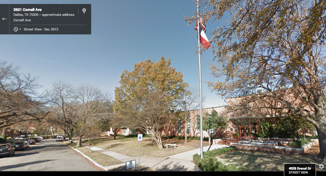
Highland Park: Armstrong Elementary (see above)
Parker: Corinth Presbyterian Church
Colleyville: Red Barn Bar-B-Que
University Park: A leafy residential block on Rankin Street
Murphy: A patch of road under construction back behind the Walmart
Southlake: The next block over from Southlake Town Square
Trophy Club: Inside a gated community that Google Street View dared not enter
Flower Mound: A residential block on Wanda Lane
Highland Village: Greenbriar Lane
Allen: Rodenbaugh’s Flooring America and Appliances
Sunnyvale: Sunnyvale High School
Keller: Keller Town Center
Coppell: A warehouse on Bethel Road
Heath: Towne Center Park
Frisco: Randy’s Steak House
Rockwall: The Old Town Rockwall Courthouse Square
McKinney: State Highway 121 under construction
Fairview: The Collin Baptist Association
Plano: Back side of a Verizon building downtown
Oak Point: Empty field on Yacht Club Road
Prosper: A house on Broadway
The Colony: McDonald’s
Grapevine: Vetro Glassblowing
Little Elm: Delilah C. King Early Learning Academy
Corinth: A house on Church Drive
Sachse: Allsup’s gas station
Ovilla: Next to First Baptist Church of Ovilla
Wylie: Wylie Eye Center downtown
Lake Dallas: Lake Dallas Elementary
Rowlett: The Rowlett Municipal Center
Forney: A jackrabbit statue
Red Oak: Walmart
Mansfield: Downtown
Roanoke: Roanoke Quik Stop
Lewisville: K&W Auto Supply downtown
Midlothian: Downtown
Richardson: Intersection of Greenville and Main
Cedar Hill: Babe’s Chicken Dinner House
Hurst: MC Snow Cones
Waxahachie: An empty building downtown
North Richland Hills: A residential block of Blaney Avenue
Bedford: Family Video
Carrollton: City Hall
Hickory Creek: Empty fields on Ellard Drive
Farmers Branch: House on Bee Street
Richland Hills: Residential stretch of Dover Lane
Euless: Taco Bell
Lancaster: Historic Town Square
Garland: Vetoni Italian Restaurant
Mesquite: Intersection of Main and Galloway
Grand Prairie: Snodgrass Discount Furniture
Irving: DART’s Downtown Irving/Heritage Crossing Station
Ennis: Avenue Automotive Repair
DeSoto: Exxon station
Glenn Heights: A residential cul-de-sac, Mesa Wood Circle
Arlington: City Hall
Duncanville: A retail row along Center Street
Seagoville: First United Methodist Church
Wilmer: First Baptist Church
Cockrell Hill: A residential stretch of Phinney Avenue
Addison: Addison Circle Park
Hutchins: WW Grocery (Home of the King Burger and Salad)
Balch Springs: Floyd Elementary