
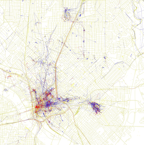

Oakland-based computer programmer Eric Fischer was interested in how locals see their city as opposed to how tourists see it. So, using publicly available data from the online photo-sharing services Flickr and Picasa, he mapped the photos taken by the two groups in various cities around the world. The map of Dallas you see here shows where geo-tagged pictures were taken over the course of two years. Blue points on the map represent pictures taken by locals (people who have taken pictures in Dallas dated over a range of a month or more). Red points represent pictures taken by tourists (people who seem to be a local of a different city and who took pictures in Dallas for less than a month). Yellow points represent pictures for which it was impossible to determine whether photographer was a visitor or a local. It seems from Fischer’s work that the hometown team likes Fair Park (bottom center blue cluster) and the Arboretum (top right), while visitors seem pretty focused on Dealey Plaza (the red on the left edge of downtown).
Related Articles

Arts & Entertainment
VideoFest Lives Again Alongside Denton’s Thin Line Fest
Bart Weiss, VideoFest’s founder, has partnered with Thin Line Fest to host two screenings that keep the independent spirit of VideoFest alive.
Local News
Poll: Dallas Is Asking Voters for $1.25 Billion. How Do You Feel About It?
The city is asking voters to approve 10 bond propositions that will address a slate of 800 projects. We want to know what you think.

Basketball
Dallas Landing the Wings Is the Coup Eric Johnson’s Committee Needed
There was only one pro team that could realistically be lured to town. And after two years of (very) middling results, the Ad Hoc Committee on Professional Sports Recruitment and Retention delivered.