
Four words describe Zada and Bill Pemberton: salt of the earth. It’s an expression that denotes a person who is trustworthy, steady, and can persevere through almost any hardship while simultaneously offering a helping hand to those around them. The Pembertons, in addition to being ace farmers with cordial manners, are in the thick of it where it concerns land currently being repurposed for recreational amenities along the Trinity — Texas Horse Park, Trinity Forest Golf Club, AT&T concrete trail project. They are gentle people who have become the eyes and ears the Great Trinity Forest, and their modest farm off Pemberton Hill Road is often the meeting place for conservationists, city employees, reporters, and more.
Their attachment to the land is understandable. A lineage of Pembertons has lived in Dallas since the 1840s. Gideon Pemberton arrived here from Kentucky as a land-grant recipient of Peters Colony. He worked as a wagon maker (ca. 1848), and it is highly probable that he, not John Neely Bryan, built, and lived in, the log cabin on display at the intersection of Elm and North Record streets. Another ancestor, Edward Case Pemberton, either a cousin or nephew of Gideon, purchased the land where Big Spring is located. Bill is the grandson of Edward Case Pemberton and since childhood, the Great Trinity Forest has been his stomping ground.
The backstory is helpful in understanding what’s on the minds of the contemporary Pembertons. Bill and Zada work around the clock with a handful of others to keep Big Spring flowing. Survival of the spring, in the eyes of many, is about the complete family, not just one, as the spring has provided habitat for aquatic life and quenched the thirst of untold numbers of insects and mammals, including humans, for thousands of years. Ben Sandifer, a well-known champion of Trinity Forest causes, says Big Spring represents life itself, a place where all things thrive, and for him, gathering around it with others is an occasion for telling “the story of water.”
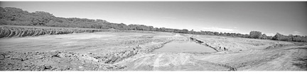
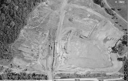
The story of water could have a tragic ending in the near future if taxpayers and Dallas city council members don’t start paying attention. Some people may be under the impression that since Big Spring has been designated a site of historic importance by both the city and state, it’s protected. That would be wrong. Some people might also think that after the infamous pond draining, tree cutting, and lack of proper Section 404 permitting in the Trinity Forest area, that the city had finally changed its ways, but that would be wrong, too. For whatever reason, the City Plan Commission (CPC), as well as the Texas Commission on Environmental Quality (TCEQ), have allowed private contractors to dig two sizable borrow pits adjacent to the soon-to-open Trinity Forest Golf Club. Those pits, grubbed and excavated on a massive scale to retrieve material for the golf course, have filled with water. One of them, the one of most concern, is called Borrow Area A. That pit is located a half mile from Big Spring.
It’s common knowledge among farmers, gravel pit operators, surveyors, and archeologists that the alluvial terraces around Big Spring hold groundwater and that it’s not necessary to dig very deep to hit it. In other words, if you dig a hole out there, it will fill up with water from the ground. Ellis W. Shuler, the SMU academic who excavated fossil elephants and made geological maps that identified sand and gravel caches with great specificity, also helped residents of Dallas County locate water. In 1918, Shuler wrote: “Over the area covered by river alluvium and in many areas underlaid by chalk and shale, shallow dug wells, 10 to 50 feet, have been sunk to supply farm houses with water.”
Brothers Ted and Hal Barker, also part of the group working to ensure Big Spring’s survival, are well known for their FOIA exploits. “The Big Dig,” as the Barkers call Borrow Area A, has been on their radar since 2014. Hal used to work in construction digging holes for piers and pits for basements, and what he saw at the site concerned him. He sized up the situation, and then he and his brother began asking questions at meetings with city engineers. If water tables of the Big Dig and Big Spring are in communication, he asked, “would that groundwater under pressure find a point of reduced resistance somewhere else?” Is it possible that the Big Dig could act as a release valve of sorts that might stop the upward flow of nearby Big Spring?
The Barkers and others had pushed for a comprehensive hydrology study from the city for years, which Hal says finally “came about the time of the Big Flood that filled up the Big Dig to bank full.” In 2015, the city hired the Thornhill Group to produce a “hydrogeological investigation,” with special emphasis on “Borrow Area A and the adjacent natural spring.” The report cost $20,000, and more than a few interested parties say it’s flawed.
According to the report, the distance between Big Spring and Borrow Area A is “more than 3,000 feet and if the pit were pumped significantly, the radial distance from the center of the pit to where there is no lowering of the water table … [would have] no effect on the discharge at Big Spring.” The bare bones assessment of the report is that water in the pit is groundwater, but the city’s nearby operations at Big Dig won’t negatively effect Big Spring.
Sandifer, who has questions about the report, says some of the empirical data collected came from “shade-tree observations.” The report bears this out, noting several times that during site reconnaissance a Trinity Watershed Management employee described how much water looked to be in the pit: “Per conversations [with TWM employee] occasionally the bottom of the pit would have about one (1) to (2) feet of water standing at the bottom of the pit, but typically, it is dry.”
Lingering questions in regard to the hydrology of both sites, says Sandifer, could be resolved quickly with dyes or isotope tracers, but to his knowledge those kinds of tests haven’t been done. Sandifer, it should be noted, is a member of the Texas Stream Team — a group of trained volunteers who gather information about the natural resources of the state. Sandifer and others — Richard Grayson, Alexander Neal, Carrie Robinson — sample and analyze the water at Big Spring at regular intervals and post data on a public site. They’re monitoring closely for changes in flow, but so far there’s been nothing alarming, other than spikes in E. coli.
It should be clear at this point of the telling that many people who spend time in the Great Trinity Forest, and those who float down the Trinity River and its tributaries in canoes, are highly competent people. It’s possible the city is too much of any unwieldy bureaucracy to handle this area with the care that is needed. The ecology of this place is in the throes of transformation; we will either have our park or we will destroy the possibility of it at the hands of our unchecked, destructive impulses.
[Editor’s note: for an explanation of the Trinity Project, go here.]