Though it often appears narrow and sluggish, the Trinity River is a workhorse. It is a complete ecosystem that needs little from people other than not getting in its way as it works to deliver water to the sea, 710 miles away. But people have gotten in its way, and a modern city has grown up around its shores and ancient floodplains. Levees have been built, rebuilt, and, from 1928 to 1931, the city removed the river’s natural meanders in advance of the promise of a barge canal. The river was not only straightened, it was moved a half a mile or more to the west.
Moving the channel from its natural course, it was positioned farther from downtown and closer to communities of color. Jim Schermbeck, a community organizer who played an instrumental role in pushing for lead cleanup in West Dallas, says those areas west and south of the river are “where all the lead smelters were located; it’s where all the landfills are; and it’s where all the metal shops, junkyards, and chemical depots went.”
Here’s another stark fact: in the Dallas-Fort Worth area, severe flooding was recorded in 1822, 1841, 1844, 1866, 1871, 1889, 1890, 1908, 1922, 1942, 1949, 1989, 1990, 1991, and 2015. The flood in 1908 prompted the city of Dallas to hire Missouri-based George E. Kessler, a landscape architect, to come up with a citywide plan that included levees, freight terminals, parks, a civic center, a belt railroad, and more. “The Trinity River,” Kessler remarked, “is the biggest problem you have in Dallas.”
And it still is. But it might not be the river per se. Rather, the problem might be the underappreciation of the river’s functionality as is. There’s also the matter of setting priorities. While new recreational amenities in and around the floodway are being pushed, neighborhoods like Cadillac Heights still don’t have levee protection. Absent in almost all discussion is the actual hydrology of the river, and that’s unfortunate because it’s an interesting story.
As mentioned in the previous essay, indigenous peoples used natural springs before Texas was Texas. Early settlers in the Dallas area used those same springs and drilled private wells that tapped into underground reservoirs called aquifers. “There is a lot of water here if you can get at it,” wrote M.E. Bolding in 1981.
The most common source for well water in Dallas County is the Woodbine Aquifer. In a U.S. Geological Survey on Dallas County, published in 1889-1900, water in the Woodbine Group was struck at a depth of between 70 feet to 1,200 feet, after passing through alluvium and Austin Chalk and Eagle Ford formations. The Woodbine Aquifer (and also the Trinity Aquifer, which is situated much deeper) is not fed by the Trinity River in Dallas County. That is, there’s no exchange or mingling of waters. According to the Texas Water Development Board (TWDB), the Woodbine and Trinity aquifers “don’t crop out in Dallas County so recharge, if any, from the Trinity River would be negligible.”
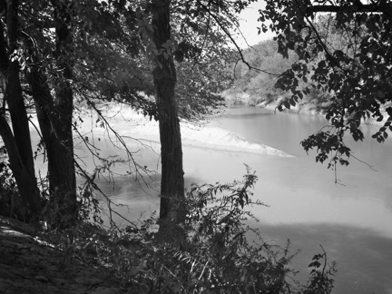
At some point in the city’s early days, clear water from springs and wells had to be augmented with surface water from the Trinity River. As the city’s population grew, so did the need for more complex waterworks that could provide a continuous supply. Though river water could be used for irrigation purposes and watering livestock, the settlers didn’t care for it for domestic uses because it tinged laundry brown. The water, then as now, carries a heavy sediment load — soil, silts, and clays — that must “settle out” to avoid the discoloration problem, in addition to bigger problems like clogged pipes.
“The water in the Trinity River through Dallas is characteristic of the land which the river runs through,” says Denis Qualls, senior program manager for Dallas Water Utilities. And in the North Texas ecoregion, “that would be farmland and blackland prairie, which equates to water that is heavily silted.” The Brazos River, on the other hand, he says, “cuts through rock, and not all of that sediment is going to be picked up.” Each river, according to Qualls, has its own characteristics, and with the Trinity, “there is quite a bit of sediment suspended in the river water.”
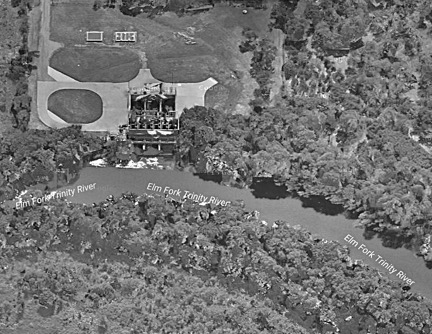
The city’s pragmatists have always understood this. At the turn of the nineteenth century, when Dallas began to upscale its waterworks, it constructed two basins for settling out sediment, called the City Water Reservoir. The basins were built near a bend in the Trinity River, at the mouth of Turtle Creek. Water from the river traveled through an intake channel to large basins, where it was impounded until sediment fell to the bottom. The water would then be pumped through pipes for municipal use.
The pump station for the early waterworks still stands and is known as the Sammons Center for the Arts. The Infomart overlies the location of the basins. And the recently constructed Strand Trail partially follows the original path of the river where water was drawn.
This general system of impoundment, settlement, and distribution is still in use today, though on a much larger scale, involving multiple players, chief among them the U.S. Army Corps of Engineers (USACE). In 1949, severe flooding in Fort Worth left nine people dead and thousands homeless. The city water supply shut down for days. As a result, Congress commissioned a new USACE district in Fort Worth.
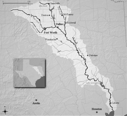
In 1950, the Fort Worth District opened with the main objectives of flood control and building reservoirs and is here to assist both Forth Worth and Dallas. The two cities and surrounding areas share a river system prone to severe, even catastrophic, floods, and both need dependable sources of drinking water. Reservoirs can collect and hold water to prevent overbanking and other flooding events, and those same waters can be released downstream for purposes of municipal supply. The three reservoirs built by the Corps in North Texas that form the core of Dallas’ current waterworks are Lewisville, Grapevine, and Ray Roberts.
When water is released from Lewisville, Grapevine, and Ray Roberts lakes, it travels down the Elm Fork of the Trinity River and enters intakes at the Elm Fork Water Treatment Plant and the Bachman Plant, both north of downtown. There, it undergoes treatment before high-service pumps move water by pipe to an ever-expanding distribution network that provides supply to elevated water tanks, businesses, households, and more.
Once water has been used, sewage and other liquid discharges flow by pipe to wastewater treatment centers like the Dallas Southside Wastewater Treatment Plant, where it’s held in basins and cleaned. It’s then released back into the Trinity River. Qualls describes the Trinity River through Dallas as “effluent dominated,” which means “there is more flow generated from treated wastewater return flows than there is naturally occurring flows (runoff from precipitation).”
According to Dr. Robert Mace, TWDB’s deputy executive administrator for the water science and conservation office, “500 million gallons per day of treated wastewater is put into the Trinity River, constituting about 50 percent of the flow downstream. During drought, that percentage rises to 80 percent.”
That’s the reality of the river, and though treated wastewater may sound disturbing, the people of Houston aren’t complaining. Without wastewater from the upper basin, the Trinity River would dry up in times of drought, which would, in turn, deplete Lake Livingston, one Houston’s main drinking water reservoirs. The bottom line is the Trinity River isn’t murky because it’s dirty; it’s murky because it carries a lot of dirt. And that will always be the case.